Nyanga National Park
One of the first national parks to be declared in the country,[2] it contains the highest land in Zimbabwe, with green hills and perennial rivers.
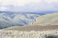
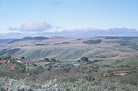
[3] Most of its terrain consists of rolling downland, sometimes lightly wooded, lying at altitudes between 1,800–2,593 metres (6,560–7,544 feet).
A wildlife checklist compiled over several years reveals a remarkable diversity of mammals, including occasional sightings of buffalo and lion that stray into the region from the Mozambique lowlands.
Visitors are likely to see kudu, reedbuck, klipspringer and several other antelope; predators, including leopard and hyaena, are also present.
The Inyangani river frog is an endangered amphibian found in rocky, fast-flowing streams in the montane grassland.
[11] Lake Gulliver and the Mare, Udu, Purdon and Rhodes Dams have been stocked with trout from hatcheries maintained by the Department of National Parks.
The park is dominated by Mount Nyangani which lies in the centre and is the highest mountain in Zimbabwe.
[16] Fifteenth to seventeenth century ruins of the Ziwa people (upland culture) have been found throughout Nyanga.
[17][18] The ruins include homesteads, centred on pit structures thought to have been used as cattle-pens and larger hill-top settlements, referred to as Forts.
[17][20] There are three sites which can be readily accessed by tourists: Chawomera Fort is located above the Nyangombe River, on a gravel road north of the park headquarters.
He acquired it with the aim of growing apples and raising sheep, and spent the last years of his life at his homestead near Rhodes Dam.
[19] There are three large rest camps in Nyanga National Park, all of which consist of fully equipped, self-catering lodges.
The larger Nyangombe camping ground, on the main highway from Mutare to Nyanga town was closed in the late 1990s.
This area also includes the main recreational facilities, such as the five dams stocked for fly-fishing and the pony trails office.
There is a four-wheel drive track that links the Pungwe Drift to Mount Nyangani, through the Nyazengu area.
The land east of Mount Nyangani was added to the park in the late 1990s and is administered from the Donjera (Gleneagles) Substation on the former Inyanga Block Estate.
The main route up Mount Nyangani is a hike, and has views across the park, much of Nyanga District and further into Mozambique.
[6] The five dams and the Kayirezi, Mare, Nyamuziwa, Nyangombe and Pungwe Rivers are stocked with rainbow trout.
Visitors may leave their vehicles at the car park and take a short hike to the edge of the escarpment for views of the waterfalls and the Honde Valley, approximately 800 metres below.