Nahalal
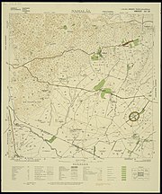
[1] Nahalal is best known for its general layout, as designed by Richard Kauffmann: slightly oval round, similar to a spoke wheel, with its public buildings at the "hub" and individual plots of agricultural land radiating from it like spokes with symmetrically placed roads creating eight equal sectors, an inner ring of residential buildings, and an outer ring road.
[citation needed] By the 20th century, Ma'alul's inhabitants were tenants of the Sursuq family of Beirut, absentee landlords who had acquired the land earlier.
They first saw the allotted land from the hill, noticing that small rivulets transformed the plain into marshes that attracted malaria-spreading anopheles mosquitoes.
Heeding the warnings of experts, such as Dr. Hillel Yaffe, the Jewish pioneers temporarily settled on a nearby hill, near the Arab village of Ma'lul.
[citation needed][dubious – discuss] The physical layout of Nahalal, devised by architect Richard Kauffmann in 1921,[7] became the pattern for many moshavim established before 1948.
[citation needed] It is based on concentric circles, with the public buildings (school, administration offices, services, and warehouses) in the centre, the homes of non-farming families (craftsmen, teachers, etc.)