Nainital
It is the judicial capital of Uttarakhand, the High Court of the state being located there and is the headquarters of an eponymous district.
From the tops of the higher peaks, "magnificent views can be obtained of the vast plain to the south, or of the mass of tangled ridges lying north, bound by the great snowy range which forms the central axis of the Himalayas.
It is believed that the Naini Lake is one of the 51 Shakti Peeths, based on the story of the death of the goddess Sati.
Out of grief and sorrow, Shiva carried Sati's body, reminiscing about their moments as a couple, and roamed around the universe with it.
After the fall of Katyuri Dynasty in 10th century, Kumaon was divided into several small princely states, and the region around Nainital was under various branches of a Khasiya family.
The Khasia chiefs made an attempt to regain their independence in 1560, when they enjoyed a brief moment of success under the leadership of a Khasiya of Ramgarh, but were later subdued with ruthlessness by Balo Kalyan Chand.
The hill station town of Naini Tal was founded only in 1841, with the construction of the first European house (Pilgrim Lodge) by P. Barron, a sugar trader from Shahjahanpur.
"[14] In 1846, when a Captain Madden of the Bengal Artillery visited Naini Tal, he recorded that "houses were rapidly springing up in most parts of the settlement: some towards the crest of the military ranges were nearly 7,500 ft (2,300 m) above sea level: the rugged and woody Anyarpatta Aashish (Anyar-patt – in Kumaoni means – complete blackout.
The reason for this nomenclature by the locals was because there were minimal sun rays due to its location and dense forests) was being gradually planted and that the favourite sites were on the undulating tract of forest land which stretched back from the head of the lake to the base of China and Deopatta (Camel's Hump).
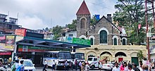
The church, St. John(1846) in the Wilderness, was one of the earliest buildings in Nainital, followed by Belvedere, Alma lodge, Ashdale Cottage(1860)..."[15] Soon, the town became a health resort favoured by British soldiers and by colonial officials and their families trying to escape the heat of the plains.
The motive power was a shock of a minor earthquake, which was felt on that day itself by competent observers in the Bhabar below and Nainital itself.
At quarter to two the major landslip occurred and within few seconds all the buildings mentioned above were destroyed and made into an unrecognisable heap of rubble and much of it was swept into the lake.
To prevent further disasters, storm water drains were constructed and building bylaws were made stricter.
[17][18][19][20] The town of Nainital covers a total area of 11.73 km2 (4.53 sq mi), and is located at 29°23′N 79°27′E / 29.38°N 79.45°E / 29.38; 79.45,[21] at an average elevation of 2,084 metres (6,837 ft) above sea level.
[22] The Krol group of rocks, comprising slates, marls, sandstones, limestones and dolomites with a few small dykes intrusives, is the dominant geological formation of Nainital's surroundings, although, Nodules, laminae and stringers of phosphatic material, followed upward by the purple-green shales intercalated with muddy fine-grained sandstone and siltstone; recognised as the Tal Formation; are also prevalent.
The town is completely located in the catchment area of the Nainital lake, which has highly folded and faulted rocks due to polyphase deformation.
The slopes are highly vulnerable to landslides and mass movement due to various geological and human factors.
The greatest landslide in Nainital occurred on 18 September 1880, on the slope which rising from the north of the flats ends at Alma peak, and resulted in 151 people being buried under the debris.
The town is a bit dry during winter and very wet during summer due to South Asian monsoon system.
It is in fact a transition between the rains and the winters and with reduced rainfall, the monthly temperature records a progressive decline till mid-January.
[27] The trees and bushes grown in the region (lake's basin) with their botanical and common Indian names (in parentheses) are: Quercus leucotrichophora Oak (Banj), Aesculus indica (Pangar or Horse chestnuts), Juglans regia (Akhrot or walnut), Populus ciliata (Hill Pipal, a sacred tree), Fraxinus micrantha (Ash tree or Angu), Platanus orientalis (Chinar), Rubus lasiocarpus (Hisalu), Rosa moschata (Kunj or Musk rose), Berberis asiatica (Kilmora), Cupressus torulosa (Surai or Himalayan cypress), Rhododendron arboreum (Buruns), Cedrus deodara (Deodar), Salix acmophylla (Weeping Willow), and Pinus (Pine).
[27] Gambusia affinis also called Mosquitofish has been introduced in the lake as a biocontrol measure to control Mosquito larvae.
[29] A special Census taken in September 1880, at the height of the tourism season, returned a total population of 10,054 for the town.
The town's religious profile is highly diverse, Nainital has a significant number of people from Muslim, Sikh and Christian communities.
The municipal board of Nainital had its origin in 1845, when the provisions of the Act I of 1842 were sanctioned by the government in the town, which then applied to approximately two thirds of the total population.
[31] He won the 2019 Indian general elections by 3,39,096 votes against Harish Rawat from the Congress, who was also the former chief minister of the state.
The Nainital zoo located on Tallital, Sher Ka Danda Hill at height of 2,100m or 6900 ft above sea level.
Its complex becomes the location of the Nanda Devi Mela festival which held every year on Nandashtami during September.
During the Victorian and Edwardian eras, students in these schools consisted largely of children of the British colonial officials or soldiers.
St. Joseph's College, Nainital (popularly known as SEM), a day-boarding and residential school built by Irish brothers.