Napo moist forests
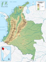
Spread over 25,174,684 hectares (62,208,000 acres),[1] the ecoregion extends from the foothills of the Andes in the west almost to the city of Iquitos, Peru in the east, where the Napo and Solimões (Upper Amazon) rivers join.
To the south it transitions into Ucayali moist forests, and into a broad belt of Iquitos várzea along the Marañón / Solimões river.
Other important Amazon basin rivers that cross the ecoregion include the Morona, Pastaza, Tigre and Curaray, and the headwaters of the Caquetá and Putumayo.
Large changes in river meanders in the Santa Cecilia region of the northwest of Ecuador may have created barriers that split species into population that then evolved independently.
Where the roads are policed, colonization by non-indigenous people is avoided but species whose meat is sold for food are rapidly depleted in areas within walking distance of settlements.
[8] As the indigenous Huaorani people become more connected to markets, their farms are expected to increase in size and the pressure on wildlife to intensify.
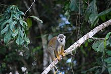
It protects the heart of one of Ecuador's last remaining areas of untouched, continuous tropical forest, a biodiversity hotspot that is one of the richest on the planet.
[6] Although a large part of the Yasuní Biosphere Reserve is undisturbed, it is in an area where the rule of law is not enforced and where immigrant farmers are advancing along roads build by oil companies and clearing forest so they can grow crops and graze livestock.