Nara Prefecture
The royal court also established relations with Sui and then Tang dynasty China and sent students to the Middle Kingdom to learn high civilization.
By 7th century, Nara accepted the many immigrants including refugees of Baekje who had escaped from war disturbances of the southern part of the Korean Peninsula.
In 784, Emperor Kanmu decided to relocate the capital to Nagaoka-kyō in Yamashiro Province, followed by another move in 794 to Heian-kyō, marking the start of the Heian period.
This clash eventually led to Kōfuku-ji and Tōdai-ji being set on fire, resulting in vast destruction of architectural heritage.
Kōfuku-ji, being the "home temple" to the Fujiwara since its foundation, not only regained the power it had before but became a de facto regional chief of Yamato Province.
As Emperor Go-Daigo chose Yoshino as his base, a power struggle arose in Kōfuku-ji with a group supporting the South and another siding the North court.
Tōdai-ji was once again set on fire in 1567, when Matsunaga Hisahide, who was later appointed by Oda Nobunaga to the lord of Yamato Province, fought for supremacy against his former master Miyoshi family.
With industry and commerce developing in the 18th century, the economy of the province was incorporated into prosperous Osaka, the commercial capital of Japan at the time.
[13][14] The first prefectural assembly of Nara was elected in the same year and opened its first session in 1888 in the gallery of the main hall of Tōdai temple.
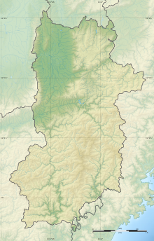
Nara Prefecture is part of the Kansai, or Kinki, region of Japan, and is located in the middle of the Kii Peninsula on the western half of Honshu.
Most of the prefecture is covered by mountains and forests, leaving an inhabitable area of only 851 square kilometres (329 sq mi).
[15] Nara Prefecture is bisected by the Japan Median Tectonic Line (MTL) running through its territory east to west, along the Yoshino River.
On the northern side of the MTL is the so-called Inner Zone, where active faults running north to south are still shaping the landscape.
South of the MTL is the Outer Zone, comprising the Kii Mountains, which occupy about 60% of the land area of the prefecture.
The Ōmine Range is in the center of the Kii Mountains, running north to south, with steep valleys on both sides.
By districts,[20] the Yamato flat inland plain holds as much as about 90% of total population within the approximately 23% size of area in the north-west, including the Nara Basin, representing a density of 1,531 people per km2.
There are large differences in dialect between the north/central region of the prefecture, where Nara city is located, and the Okunoya district in the south.
Association football Basketball Many jinja (Shinto shrines), Buddhist temples, and kofun exist in Nara Prefecture, making it is a centre for tourism.
Moreover, many world heritage sites, such as the temple Tōdai-ji and Kasuga Shrine, exist in the capital city of Nara.


City Town Village


