Narvik Municipality
Some of the notable villages in the municipality include Ankenesstrand, Ballangen, Beisfjord, Bjerkvik, Bjørnfjell, Elvegården, Kjøpsvik, Skjomen, Håkvik, Hergot, Straumsnes, and Vidrek.
The municipality is part of the traditional district of Ofoten of Northern Norway, inside the Arctic Circle.
The mountain peak has a tincture of argent which means it is commonly colored white, but if it is made out of metal, then silver is used.
The official blazon is "Gules, an anchor Or" (Norwegian: På rød bunn et opprett gull anker).
The anchor symbolises Narvik's status as an important port (the largest harbour in North Norway).
The town of Narvik was developed as an all-year ice free port for the Swedish iron mines in Kiruna and Gällivare .
The history of modern Narvik begins in the 1870s, when the Swedish government began to understand the potential of the iron ore mines in Kiruna, Sweden.
[16][17] The Swedish company (Gällivarre Aktiebolag) built the Iron Ore Line (Malmbanan) to Riksgränsen on the Norway–Sweden border.
Swedish mining corporation LKAB still ships the majority of its ore from Narvik (a total 25 million tons a year).
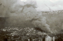
[17] The port of Narvik proved to be strategically valuable in the early years of World War II and the town became a focal point of the Norwegian Campaign.
During the summer season, this ore could be sent by cargo ship to Germany through the Baltic Sea via the Swedish port of Luleå on the Gulf of Bothnia.
However, when the Gulf of Bothnia froze during the winter, more shipments of the ore needed to be transported through Narvik and, from there, down the west coast of Norway to Germany.
As a result, Narvik serves as a gateway to the ore fields of Sweden that cannot be easily reached from southern Norway via land.
Winston Churchill realized that the control of Narvik meant stopping most German imports of iron ore during the winter of 1940.
Equally as important, later in the war, German submarines and warships based there threatened the allied supply line to the Soviet Union.
[18] Churchill proposed laying a naval minefield in Norwegian territorial waters around Narvik (referred to as "the Leads"),[18] or else occupying the town with Allied troops.
The Allies hoped that they might be able to use an occupied Narvik as a base from which to secure the Swedish ore fields and/or to send supplies and reinforcements to Finland, then fighting the Finnish Winter War with the Soviet Union.
[18] Finally, on 8 April 1940, the British Admiralty launched Operation Wilfred, an attempt to lay anti-shipping minefields around Narvik in Norwegian territorial waters.
The Admiralty argued that a naval bombardment of Norway would enable the troops to land safely, but General Mackesy refused to subject Norwegian citizens to such a bombardment, and instead he chose to land his troops near Narvik and wait until the snow melted to take over the town.
The same day, while operating in the Narvik area, the German battleships Scharnhorst and Gneisenau sank the British aircraft carrier HMS Glorious during the withdrawal from this battle.
[19] Without support from the Allied naval task force, the Norwegians were outnumbered, and they had to lay down their arms in Norway on 10 June 1940.
Some of the other settlements in the municipality are Bjerkvik (located at the head of the Herjangsfjord), Håkvik, Beisfjord (along the Beisfjorden) and Skjomen.
The eastern part, towards the border with Sweden, is dominated by mountains, including the 1,893.7-metre (6,213 ft) tall Storsteinfjellet which is the highest point in the municipality.
There are also valleys such as the Vassdalen and many, many lakes, including the lakes Baugevatnet, Båvrojávrre, Børsvatnet, Gautelisvatnet, Geitvatnet, Hartvikvatnet, Hjertvatnet, Indre Sildvikvatnet, Iptojávri, Kjelvatnet, Langvatnet, Lossivatnet, Melkevatnet, Rødvatnet, Sealggajávri, Siiddašjávri, Søndre Bukkevatnet, Storvatnet, Tjårdavatnet, and Unna Guovdelisjávri.
The town itself is situated near the innermost part of the deep Ofotfjorden, but even here the mountains, going almost straight up from the blue fjord, reach as high as 1,700 metres (5,600 ft) in Skjomen, where the glacier Frostisen can be seen.
Forests cover the lower parts of the mountains (below 500 metres), but near the summits, the snow can stay most of the summer.
[42] The mountains surrounding the town in reality extend this period from early November until the end of January.
The reason is that the railway and ocean distances using this route are shorter than through central Europe to Western European ports.
The museum displays the Victoria Cross awarded posthumously to Captain Bernard Warburton-Lee of the British Royal Navy and a rare German Enigma coding machine.
The building that houses Museum Nord - Narvik was erected in 1902 as the head office of the Norwegian state railway company, Norges statsbaner and was designed by architect, Paul Due.


(Borders as of 1920–1940.)