National Route 7 (Argentina)
National Route 7 (full name in Spanish: Ruta Nacional 7 Carretera Libertador General San Martín) is a road in Argentina.
The Western Camino Real started at Buenos Aires, ran through San Luis and Mendoza, and ended at Santiago de Chile.
In 1935, that organisation started work on a new road parallel to a railroad operated by Buenos Aires and Pacific Railway (which later became Ferrocarril General San Martín).
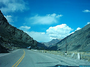
[4][5][6] To reach Mendoza and Uspallata, the road goes through the "Caracoles de Villavicencio", a mountain section with altitudes of around 3000m, and 365 bends.
[7] The next step was to upgrade the road to a highway for the section uniting the cities of San Martín and Mendoza.
They also designed and build a modification of the original section of the road starting near the Mendozan city of La Paz, diverting it approximately 1.5 km to the north, to pass nearer some towns.
The original 140 km section was transferred to the jurisdiction of Mendoza Province, and is now called Provincial Route 50.
In 1979, National Directive 1595[8] transferred jurisdiction of the old Las Heras - Villavicencio - Uspallata (97.2 km) section to Mendoza Province, and it now forms Provincial Route 52.
This is a zigzagging road from Las Cuevas to La Cumbre Pass, where you can see the statue Christ the Redeemer of the Andes.
Access from the city of Buenos Aires to Luján was formerly by an avenue circling parallel to the tracks forming part of Ferrocarril Domingo Faustino Sarmiento.
[11] "Access West", the highway joining Avenida General Paz with Luján, was built in various stages over more than 20 years.
It takes a slightly different route to the original road around the provincial capital and passes further south, i.e. further from the city centre.
The government of San Luis converted it into an expressway which opened on 27 July 2007 as Avenida Parque Gobernador José Santos Ortiz.
[16] This part of the route generated controversy during the planning period because it passed through an important paleontological deposit.
The affected area was between Aarón Castellanos and Diego de Alvear, along the border between the provinces of Santa Fe and Buenos Aires.
But until 2004, the Junín - Villa Mercedes section did not have any service stations selling compressed natural gas (CNG),[23] so vehicles that relied on this fuel diverted along National Route 8 instead.
The National Gendarmarie run an AM and FM radio station that gives information on road conditions, plays music and reads the day's news headlines.
[32][33] At the same time, the company Caminos del Oeste took charge of Road Corridor 3, which included Route 7 km 490-999, from Laboulaye as far as San Martín (Mendoza).
In 1993 companies were invited to place bids to extend Access West from Avenida General Paz to Luján.
[30] The 180 km stretch between National Route 40 and the Chilean border has been managed by recovery and maintenance contracts since 1 January 2007.
[38] Route 7 is divided into 20 sections in Buenos Aires, 2 in Santa Fe, 5 in Córdoba, 13 in San Luis and 15 in Mendoza.
The section with the highest traffic is the most eastern 10 km of the route, with an annual average daily load of 82,500 vehicles per day in 2001.
The lowest volume of traffic occurs around La Picasa Lake where the route has been cut off by water since the measurements began.
On the west of the province, the route runs through the main and front ranges, and passes only 18 km south of Aconcagua, the highest mountain in the Americas.
Until the construction of the Túnel del Cristo Redentor in 1980, the route finished at 3,832 msnm at Paso Internacional de la Cumbre, where it ended at the statue of Christ the Redeemer of the Andes.
Due to the extreme height, the mountain pass is cut off for several days during the winter months because of snowdrifts on the road.
To relieve the situation, they started to pave National Route 145 in the southwest of Mendoza Province, which joins the neighbouring republic to the Pehuenche passage lower down so it doesn't have the same problem.
The graph on the left shows the height of the road between the junction with National Route 40 on the outskirts of Mendoza city and Avenida General Paz.
The biggest attraction is the Lake Gómez natural park, which is ideal for water sports, relaxation and fishing.
There is also the Andinista Cemetery, the entrance to Aconcagua Provincial Park, several viewpoints, and a zigzag road leading to the Chilean border where the Cristo Redentor statue stands.