National Waterway 4
It connects the Indian states of Telangana,[1][2] Andhra Pradesh, Tamil Nadu, and the union territory of Puducherry.
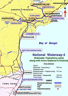
The NW-4 runs along the Coromandal Coast through Kakinada, Eluru, Commanur, Buckingham Canals and also through part of Krishna and Godavari rivers in South India.
[9] In July 2006, T. R. Baalu, the Minister of Shipping, Road Transport and Highways announced the proposal for development of NW-4 in the Lok Sabha.
The Krishna River section stretches from Wazirabad Nalgonda district, Telangana to Prakasam Barrage, Vijayawada, Andhra Pradesh.
Starting from Dowleiswaram on the left bank of the river Godavari through a head sluice and lock to Kakinada (approx.
It runs between Vijayawada to Vijjeswaram lock at Sir Arthur Thomas Cotton Barrage for a total distance of 139 km (86 mi).
The lengths of the NW-4 in Andhra Pradesh, Tamil Nadu, and Puducherry are as follows:[15] The concept of National Waterways was introduced in 1982 to promote the development of inland water transport in the country.
Development works are being carried out with the objective of making all three National waterways fully operational with cargo and other inland vessels by March 2012.
[16] Techno-economic studies for establishment of National Waterways NW-4 was done by Water And Power Consultancy Services (WAPCOS), a subsidiary of Ministry of Water Resources The completion period for NW-4 was estimated at seven years by Detailed Project Report prepared by WAPCOS, which is contrary to that of 2002 estimates which indicated five years as completion period.
The main reason for lack of IWT movement is the absence of other infrastructure facilities and coordinated effort for improvements.
Main cargo to be transported in downstream direction from kakinada to rajahmundry are coal, fertilizer, salt and rock Phosphate.
In the upstream direction, rice bran extractions, cement clinker and fertilizers will be the main cargos for transportation.
The stretch from Vijayawada to Peddaganjam (Ongole) is a vital trade link connecting Kakinada belt with south A.P and Tamil Nadu.
Rice, food grains, fertilizers, chili peppers, tobacco, fish, granite and vegetables in the downstream direction from Peddaganjam to Chennai.
The stretch of Buckingham Canal saved thousands of lives in the states of Andhra Pradesh and Tamil Nadu along the coromandal coast from tsunami waves, that occurred on 26 December 2004.
Dr. B. Ramalingeswara Rao of National Geophysical Research Institute (NGRI), Hyderabad reports that the Buckingham Canal acted as a buffer zone and regulated the tsunami waves on the coastal region over 310 km (190 mi) from Pedda Ganjam to Chennai.
[18][19] The canal from Chennai (Marakkanam) to Durga Raya Patnam near Nellore and then to Pedda Ganjam, all along the east coast was filled with tsunami water, which overflowed at a few places and receded back to sea within 10–15 minutes.
The cost was re-estimated by WAPCOS in 2009 to ₹1,515 crore (equivalent to ₹38 billion or US$440 million in 2023), which involves two phase development of the project.