Northeast India
[18] It comprises eight states—Arunachal Pradesh, Assam, Manipur, Meghalaya, Mizoram, Nagaland and Tripura (commonly known as the "Seven Sisters"), and the "brother" state of Sikkim.
[23] Due to the biodiversity and crop diversity of the region, archaeological researchers believe that early settlers of Northeast India had domesticated several important plants.
[24] Historians believe that the 100 BCE writings of Chinese explorer Zhang Qian indicate an early trade route via Northeast India.
[25] The Periplus of the Erythraean Sea mentions a people called Sêsatai in the region,[26] who produced malabathron (cinnamon-like aromatic leaves, dried and used as a flavouring agent), so prized in the old world.
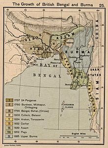
[29] The northeastern states were established during the British Raj of the 19th and early 20th centuries, when they became relatively isolated from traditional trading partners such as Bhutan and Myanmar.
[citation needed] Initially, the Japanese had invaded British territories in Southeast Asia, including Burma (now Myanmar), with the intention of creating a fortified perimeter around Japan.
The British had neglected the defence of Burma, and by early 1942, the Japanese had captured Rangoon and pushed Allied forces back towards India through a gruelling retreat.
[40] In response to the Japanese advance, the British formed the South East Asia Command (SEAC) under Admiral Lord Louis Mountbatten in November 1943.
This command brought new energy to the war effort in the region and emphasised the importance of standing firm and fighting on despite logistical challenges, such as during the monsoon season.
The Allied victory paved the way for subsequent offensives to clear Japanese forces from Burma and ultimately led to the re-conquest of the region.
The sobriquet 'Land of the Seven Sisters' was coined to coincide with the inauguration of the new states in January 1972 by Jyoti Prasad Saikia,[47] a journalist in Tripura, in the course of a radio talk show.
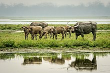
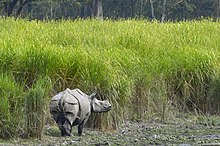
Along with the west coast of India, this region has some of the Indian subcontinent's last remaining rainforests, which support diverse flora and fauna and several crop species.
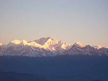
[citation needed] Kangchenjunga, the third highest mountain peak in the world rising to an altitude of 8,586 m (28,169 ft), lies in-between the state Sikkim and adjacent country Nepal.
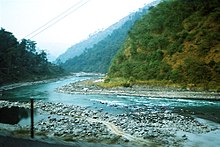
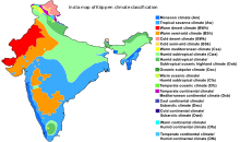
[51] It is the rainiest region in the country, with many places receiving an average annual precipitation of 2,000 mm (79 in), which is mostly concentrated in summer during the monsoon season.
[54][55] At altitudes between 500 and 1,500 m (1,600 and 4,900 ft) located in the eastern hills of Nagaland, Manipur and Arunachal Pradesh, a (Cfb/CWb) climate prevails with warm summers.
[62] In the hilly parts of Mizoram, the closer proximity to the Bay of Bengal causes it to experience early monsoons with June being the wettest season.
[62] The North Eastern Region of India is a mega-earthquake prone zone caused by active fault planes beneath formed by the convergence of three tectonic plates viz.
Conservation International has upscaled the Eastern Himalaya hotspot to include all the eight states of Northeast India, along with the neighbouring countries of Bhutan, southern China and Myanmar.
The EBA has an area of 220,000 km2 following the Himalayan range in the countries of Bangladesh, Bhutan, China, Nepal, Myanmar and the Indian states of Sikkim, North Bengal, Assam, Nagaland, Manipur, Meghalaya and Mizoram.
Sino-Tibetan is represented by a number of languages that differ significantly from each other,[78] some of which are: Boro, Rabha, Karbi, Mising, Tiwa, Deori, Hmar (including Biate, Chorei, Halam, Hrangkhawl, Kaipeng, Molsom, Ranglong, Saihriem, Sakachep, Thangachep, Thiek), Zeme Naga, Rengma Naga and, Kuki (Thadou language) (Assam); Garo, Rabha, Hmar (including Biate, Sakachep) (Meghalaya); Ao, Angami, Sema, Lotha, Konyak, Chakhesang, Chang, Khiamniungan, Phom, Pochury, Rengma, Sangtam, Tikhir, Yimkhiung, Zeliang, Kuki (Thadou), and Hmar (including Sakachep/Khelma) etc.
The region's population results from ancient and continuous flows of migrations from Tibet, Indo-Gangetic India, the Himalayas, present Bangladesh, and Myanmar.
[citation needed] All states in Northeast India share the handicrafts of bamboo and cane, wood carving, making traditional weapons and musical instruments, pottery and handloom weaving.
[105][106] Some of the notable writers of Northeast Literature are--(from Assam) Lakshminath Bezbaroa, Homen Borgohain, Birendra Kumar Bhattacharya, Harekrishna Deka, Rongbong Terang, Nilmani Phukan, Indira Goswami, Hiren Bhattacharyya, Mitra Phukan, Jahnavi Barua, Dhruba Hazarika, Rita Chowdhury; (from Arunachal Pradesh) Mamang Dai; (from Manipur) Robin S Ngangom, Ratan Thiyam; (from Meghalaya) Paul Lyngdoh; (from Nagaland) Temsula Ao, Easterine Kire; (from Sikkim) Rajendra Bhandari.
These sports include football, with Mizoram's Talimeren Ao having served as the first captain of the national team in 1948,[109] and a growing presence of baseball in Manipur.
[citation needed] Several militant groups have formed an alliance to fight against the governments of India, Bhutan, and Myanmar, and now use the term "Western Southeast Asia" (WESEA) to refer to the region.
The North Eastern Development Finance Corporation Ltd. (NEDFi) is a public limited company providing assistance to micro, small, medium and large enterprises within the northeastern region (NER).
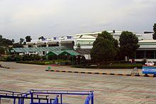
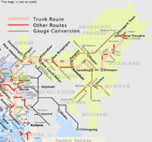
[citation needed] States in the North Eastern Region are well connected by air-transport conducting regular flights to all major cities in the country.
With 98 per cent of its borders with China, Myanmar, Bhutan, Bangladesh and Nepal, Northeast India appears to have a better scope for development in the era of globalisation.
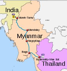
Another major constraint of surface infrastructure projects in the NE states has to be linked up with parallel developments in the neighbouring countries, particularly with Bangladesh.
The restoration and extension of pre-partition land and river transit routes through Bangladesh is vital for transport infrastructure in NE states.