Nazca Ridge
[9] Based on isotopic ratios and rare earth element composition, it is estimated that the magma was sourced at approximately 95 km depth from a 7% partial melt.
[10][2] Magnetic anomalies have shown that there was symmetrical spreading at the Pacific-Farallon/Nazca center, so the Tuamotu Plateau can be used as a proxy for the pre-subducted Nazca Ridge geometry.
[2] Based on Tuamotu Plateau mirror relationship, it is estimated that 900 km (560 mi) of the Nazca Ridge has already subducted.
[11] The extreme thickness of the buoyant ridge is responsible for the flat slab subduction of the older underlying plate.
Large magnitude earthquakes occur in association with the area around the Nazca Ridge subduction zone, known at the Peru megathrust.
[7] Crustal erosion of the forearc basin has resulted in the loss of 110 km (68 mi) of the South American plate since 11 Ma.
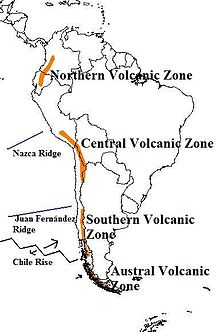
[5] The flat slab subduction associated with the Nazca Ridge has been linked to the cessation of volcanism in the Andes Mountains at about 4 Ma.
[6] The subduction has also been linked with the formation of the Fitzcarrald Arch, which is a 400,000 km2 (150,000 sq mi), 400 to 600 m (1,300 to 2,000 ft) high, domed topographic feature that defines the Amazon drainage Basin.
[6] The uplift of the Fitzcarrald Arch intersects with the Andes Mountains where there is a shift from high-gradient topography to the low-gradient Amazon Basin.
[1] This topographic uplift effectively divides the Amazon drainage basin into three sub-basins, the Ucayali to the northwest, the Acre to the northeast, and the Madre De Dios to the southeast.
[17] The uplift of the Fitzcarrald Arch could also be the catalyst that lead to these differing evolutionary paths, effectively isolating fish populations from each other.