Nelson, Lancashire
[8] The coming of the Leeds and Liverpool Canal in 1796, followed by the East Lancashire Railway Line in 1849,[9] spurred its development as an industrial town, with an economy based mainly upon cotton weaving.
The first Ordnance Survey map of the area, published in 1848, shows three small villages: Marsden (around St Paul's), and Hebson and Bradley, both on Walverden Water in the modern-day centre of town.
As the villages developed into a town, the name Nelson was chosen to differentiate it from Marsden across the Pennines in the neighbouring (West Riding of Yorkshire).
[12] The cotton industry was the most important in the town, and by 1910, more than 12,000 local workers were members of the Nelson and District Power-Loom Weavers' Association.
There is evidence of old bell pits and surface mining at Swinden Clough and Castercliff,[8] and as early as 1465 there was a complaint of people unlawfully digging coal in the area.
The textile industry, in particular, has now sharply declined, leaving the town with low property prices and higher than average unemployment.
The council refused, moreover, to participate in celebrations for King George V's silver jubilee in 1935, saying that they would rather spend public money on free dinners for school children and the jobless.
After boundary changes in 2020 which reduced the number of wards in the borough to 12, four cover parts of Nelson parish – Bradley, Brierfield East & Clover Hill, Marsden & Southfield and Whitefield & Walverden.
[19][20] Pendle Borough Council is currently under 'No Overall Control' and governed by a coalition of independents and Liberal Democrats, led by Councillor Mohammed Iqbal.
[21] The Member of Parliament for Pendle and Clitheroe, the constituency into which the town falls, is Jonathan Hinder (Labour), who was first elected in 2024.
Stores currently include: Boots, Specsavers, Home Bargains, Peacocks, Greggs, Post Office, and Martin McColl.
The main road through the town centre, pedestrianised in the early 1990s, was reopened to traffic in August 2011, to help boost trade.
A 31-hectare site was taken out of the Green Belt when the council's new Local Plan was adopted in December 2015, to facilitate a further extension to the west and north.
The Lomeshaye Business Village, a refurbished former cotton mill to the east of the estate, contains a further 151 units, principally occupied by small and medium-sized enterprises engaged in office and light industrial uses.
[citation needed] Nelson is served by Junction 13 of the M65 motorway, which runs west to Burnley, Accrington, Blackburn and Preston, and north-east to Colne.
From the town centre, the A56 runs southwest to the M65 at Brierfield and north-east to Colne and beyond, while the A682 – Britain's most dangerous road[28] – heads north into the Yorkshire Dales.
[31] The new interchange facility cost £4.5 million and included enhancements such as cycle stands, taxi and car drop-off facilities, electronic information displays, a direct link to the railway station including a passenger lift and an enclosed passenger concourse with 10 bus stands.
The Interchange has an hourly stopping service 7 days a week west to Blackpool South via Blackburn and Preston, and east to Colne.
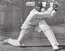
[34] Nelson Cricket club has a significant success record, with 21 Lancashire League championship titles to its name.
One has resulted in the restoration and conservation of a whole street of Victorian workers housing, a former primary school and cotton mill, as it was feared that the industrial heritage of the town was at risk.
[44] St Mary's Church is also another major project in the town, which is planned to open as an exhibition centre in Summer 2012.