Nerang River
The Nerang River rises in the McPherson Range in the Numinbah Valley on the New South Wales and Queensland border and heads north, then east where it flows through Nerang and reaching its mouth in the Gold Coast Broadwater at Southport on the Gold Coast and emptying into the Coral Sea.
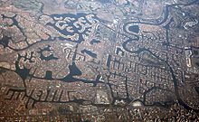
[4] In the river's lower catchment, multi-branched canal developments and a number of artificial tidal and freshwater lake systems have influenced and altered large aras of the floodplain.
[citation needed] In June 1967, the development of an east coast low lead to the rising of waters in the river that went on to flood significant lands upriver from Surfers Paradise.
[9] The City of Gold Coast council's "Surfers Riverwalk" coastal pathway links[10] Sundale Bridge, Macintosh Island, Budd's Beach, Surfers Central Riverwalk, Cascade Gardens, the Gold Coast Convention and Exhibition Centre, Casino Island and Pacific Fair Shopping Centre.
Boat ramps that are open to the public are located at Waterways Drive at Main Beach, Budds Beach, Evandale, on the Isle of Capri, TE Peters Drive at Broadbeach Waters (Convention Centre), Carrara Road, Carrara, and at the Nerang River Parklands.
[11] A major ongoing project is control of the invasive cats claw creeper, registered as a Weed of National Significance.