Neretva
The Neretva (Serbian Cyrillic: Неретва, pronounced [něreːtʋa]), also known as Narenta, is one of the largest rivers of the eastern part of the Adriatic basin.
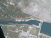
Four hydroelectric power plants with large dams (higher than 15 metres)[2] provide flood protection, electricity and water storage.
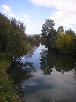
The Neretva is notable[6][7] among rivers of the Dinaric Alps region, especially regarding its diverse ecosystems and habitats, flora and fauna, cultural and historic heritage.
[11] Its source and headwaters gorge are situated deep in the Dinaric Alps at the base of the Zelengora and Lebršnik mountains, specifically under the Gredelj saddle.
From Jablanica, the Neretva enters third and the largest canyon on its course, running through the steep slopes mountains of Prenj, Čvrsnica and Čabulja reaching 800–1,200 metres (2,625–3,937 feet) in depth.
[13] Rivers of the Tatinac (also known as the Jezernica), the Gornji Krupac and Donji Krupac, the Ljuta (also known as the Dindolka), the Jesenica, the Bjelimićka Rijeka, the Slatinica, the Račica, the Rakitnica, the Ljuta (Konjička), the Trešanica, the Neretvica, the Rama, Doljanka, the Drežanka, the Grabovica, the Radobolja, and the Trebižat flow into the Neretva from the right, while the Jezernica, the Živanjski Potok (also known as the Živašnica), the Lađanica, the Krupac, the Bukovica, the Šištica with its Šištica Waterfall, the Bijela, the Idbar, the Glogošnica, the Mostarska Bijela, the Buna, the Bregava, and the Krupa flow into it from the left.
[14] Rising from the base of the Zelengora and Lebršnik Mountain, Neretva headwaters run in undisturbed rapids and waterfalls, carving steep gorges reaching 600–800 metres (2,000–2,600 ft) in depth.
Here the Neretva river suddenly takes an almost 180° turn towards the east-southeast and flows for a short leg before it reaches the town of Jablanica.
From this point it turns again toward the south and enters the third and largest canyon on its course, running through the steep slopes of the mountains of Prenj, Čvrsnica, and Čabulja, reaching between 800–1,200 metres (2,625–3,937 feet) in depth.
Further downstream two much larger vales appear again on each side, first on the right the stream of Drežanka and its large and steep valley, with two eponymous villages, Donja (Lower) and Gornja (Upper) Drežnica, and than Mostarska Bijela, as one of the most pristine vales in Bosnia and Herzegovina, with its eponymous uniquely characteristic subterranean stream, embedded deep into the Prenj mountain, on the left.
Although these streams are of low outflow, there are also numerous wellsprings rising on both sides of the canyon at the river banks, with high-capacity discharge.
[2] Downstream from the confluence of its tributaries, the Trebižat and Bregava Rivers, the valley spreads into an alluvial fan covering 20,000 hectares (49,000 acres).
Gornje Blato-Deransko Lake is supplied by the karstic water sources of the Trebišnjica River, emerging from bordering hills.
[18] Passing towns and villages in Bosnia and Herzegovina, the Neretva spills out into the Adriatic Sea, building a wetland delta that is listed under the Ramsar Convention as internationally important.
[19][16] In this lower alluvial valley in Croatia, the Neretva River splinters into multiple courses, creating a delta covering approximately 12,000 hectares.
The fast pace of pike perch population growth and displacements is expected to match the environmental conditions from the mid-ecological valence of this fish.
Parallel with the increase in pike perch is a decrease in endemic indigenous species like European chub also white chub (Squalius cephalus), and the disappearance of rare and endemic species like Adriatic Dace also Balkan dace (Squalius svallize also Leuciscus svallize Heckel & Kner 1858), Neretvan softmouth trout (Salmothymus obtusirostris oxyrhinchus Steind.)
[28] All three endemic trout species of the Neretva are endangered, mostly due to the habitat destruction or construction of large/major dams ("large" is higher than 15–20 m; "major" is over 150–250 m).
[2] Other problems include hybridization or genetic pollution with introduced, non-native trouts, illegal fishing and poor water and fisheries management.
[2] These facilities are as follows: There are additionally a number of hydroelectric power station of various capacities on smaller tributaries, such as Mostarsko Blato Hydroelectric Power Station on the Lištica (downstream from HPP named Jasenica), Peć Mlini Hydroelectric Power Station on the Trebižat, and numerous small hydro projects on the small river tributaries like Tatinac, Trešanica, Neretvica and Duščica, with a proposed small hydro on the rivers Doljanka, Glogošnica, and one abandoned on the Idbar.
[5][19][42][43][44] Meanwhile, Bosnia and Herzegovina entity, Federation of Bosnia and Herzegovina, was preparing a parallel plan to form a large, protected area as a national park which would include the entire region of Gornja Neretva (English: Upper Neretva), and have within the park the three hydroelectric plants.
Such drastic disregard in planning and designing, considering that the facilities of HE Ulog are located on the very line of demarcation of two ethnically based entities, which makes the downstream of the river located entirely in another administrative entity, where all the ecological consequences resulting from the use of Neretva water and the production of electricity will be felt exclusively, introduces, besides environmental, also an ethnic and political dimension to the issue.
The find is unique in a European perspective and archaeologists have concluded that Desilo, as the location is called, was an important trading post of great significance for contact between the Illyrians and the Romans.
Archaeological finds include the ruins of a settlement, the remains of a harbour that probably functioned as a trading post, as well as many sunken boats, fully laden with wine pitchers – so-called amphorae – from the 1st century BC.
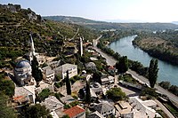
[citation needed] Gabela is a rich archaeological site on the Neretva bank, situated 5 km (3 miles) south of Čapljina.
Along with notable medieval buildings, remains of Old City walls, and a sculpture of a stone lion – a symbol of Venetian culture survived.
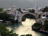
Charged under pain of death to construct a bridge of such unprecedented dimensions, the architect reportedly prepared for his own funeral on the day the scaffolding was finally removed from the completed structure.
Codenamed Fall Weiß, the operation was a German plan for a combined attack launched in early 1943 against Yugoslav Partisans throughout occupied Yugoslavia.
Near Jablanica, 20,000 Partisans under command of Marshal Josip Broz Tito struggled to save some 4500 wounded comrades and typhus patients together with the Supreme Headquarters and Main Hospital, against some 150,000 Axis combatants.
[68] Celebrated Bosnian and Herzegovinian poet, Mak Dizdar often used the river Neretva as motif in his poetry, alongside other historical, cultural and natural feature of his native Herzegovina.