Nave Sha'anan, Haifa
'tranquil abode') is a large residential neighborhood in eastern Haifa, Israel that extends from the lower inclines of Mount Carmel to midway across its slopes.
Nave Sha'anan was founded in 1922[2] as an isolated rural neighbourhood on the Carmel mountain with typical one storey family homes, some of which can still be glimpsed here and there.
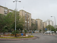
In recent years it is undergoing a rapid process of renovation and replacement of older homes by new high rise residential blocks.
However, it is common to refer to the entire area surrounding Nave Sha'anan by the same name, and in that case the population is greater than 80,000, constituting the largest Israeli "single" neighbourhood.
[4] In recent years Nave Sha'anan came to house a major transportation hub in the wider Haifa area.
[citation needed] Haifa Municipality divides Neve Sha'anan into two statistical quarters.
The slopes of Neve Sha'anan include the old neighborhoods of Halisa and Tel Amal, both of which were built before the establishment of the state of Israel, east of the Gesher Hagiborim (the heros' bridge) and along the transportation artery that forms the lower city and Neve Sha'anan, through Yad Labanim, and the streets that branch off from it.
The main street, Carmeli Division, continues east and meets Derech Yaakov Dori in Neve Sha'anan.
Neve Yosef - intersection of Yad Labanim Road and Arad Street This neighborhood, named after Yosef Erdstein, the leader of Haifa workers during the Mandate period, is located in the northern foothills of Neve Sha'anan.
Neve Paz was established after Amal, and is located between Yad Road and Labin in Shemen Beach.
The Jezreeliya neighborhood, where about 10,770 people lived in 2007, was built after the clearing of the crossings and has high-rises and rows of "railway buildings".
On the outskirts of the neighborhood, the "Sportech" garden was inaugurated in 1980, for the purpose of which Wadi Rushmia was filled with quarry waste for 4 years.
On the western outskirts of Jezreeliya and Neve Sha'anan there was a British military camp where the legion soldiers were stationed during the Mandate.
The expanded neighborhood includes the western part of Trumpeldor Boulevard, Shalom Aleichem and Gilboa Streets, Berel Katznelson Street - which surrounds Ziv in a semi-circle, as well as the small neighborhoods "Shahar" (when it was founded it was called "Naot Shahar", later it was renamed "Ben Square -earthly") and "Bemsila" ("Shikon Solel Bona").
The streets leading out of the square, namely Trumpeldor Boulevard and Shalom Aleichem and Berel streets, have always served as the main business center for the entire Neve Sha'anan, where you can find bank branches, offices, restaurants and shops of all kinds.
Near the square there used to be the "Ziv" cinema, which was closed, as well as a supermarket that for decades belonged to the cooperative association "The Consumer" and was sold to the ultra-Orthodox "Bar Khol" chain.
Ramat Alon is bordered to the east by the Technion, to the west by Ramot Ramez, to the north by Ziv, and to the south and southwest by Dania.
The majority of its residents are young families, students and permanent army personnel, who were the original population at the time of its planning.
The Wall of the Crows is the name of an archaeological site located north of the neighborhood at the foot of a cliff located near the access road to the Technion (Meir Yaari Street), and it includes a cave and several alcoves where tools were found indicating a prehistoric settlement.
About 60 meters north of the cliff, a large building was discovered that was used, apparently as an agricultural farm from the Hellenistic period.
The first houses of Ramot Remez, an old neighborhood founded in 1949, were built in low-rise construction along International Street, Hankin Road opposite it and in the small streets branching off International, in a typical layout of two-story houses with red tiled roofs.
In the beginning, the neighborhood, named after David Ramez, was used as housing for veterans for the working class, mainly for veterans of the General Histadrut, and as housing for members of the permanent army (Shachak) on Dorot, Hala and Borchov streets.
Ramot Ramez is popular among students (25% of its population in 2004) due to its location between the Technion and Haifa University and its relatively low prices.
The construction of the neighborhood was completed in the first decade of the 21st century on a hill that used to be called "Contractors' Hill" to the east of Ramot Sapir, and is bordered to the south by Hankin Road, to the west by Nahal Ramez and Ramot Sapir, to the north by Nahal Sha'anan and Simcha Golan Road, and to the east by the Ziv neighborhood.
At the edge of the neighborhood, a luxury sheltered housing building named "Pisgat Chen" was built, founded by the organization of Central European immigrants.
The boundaries of the neighborhood are expected to be Hankin Road to the north, Ramot Ramez to the east, Pliman Hospital and Ramat Almogi to the south, and Givat Oranim to the west.
In addition, it was confirmed that the squares will be named after the bands the Dodaim, Meshina, Hagavetron, Halb and Dvash, and Korat, and the streets will be named after Yaffe Yarkoni, Shoshana Demari, Ehud Manor, Naomi Shemer, Yossi Banai, Yehuda Amichai, Ofra Haza, Yohoram Gaon and Jordana Arzi.
The complex also operates a religious cultural center for youth, which is responsible for activities such as plays, classes, lectures, and hosting cantors; The H. Aivshitz Institute for Holocaust Studies and the neighborhood branch of the Bnei Akiva movement are also part of this complex.
During the 1980s, a yeshiva "Nachlat HaLeviim" was established on the synagogue's grounds and the area adjacent to it under the leadership of Rabbis Israel Meir Weiss and Ori Weissbloom.