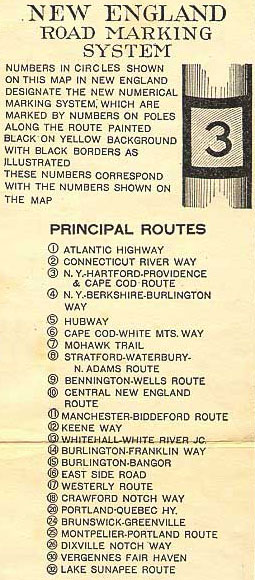
New England road marking system
Vermont's system was unique because route colors were not determined by direction, but by funding and responsibility for maintenance.
In 1908, the New York legislature had laid out 37 routes slated for maintenance solely by the state, but there was no proper numbering until 1924.
In April 1922, delegates from the New England states met at a dinner conference hosted by the Automobile Club of America to coordinate a new system.
The highway continued east to Old Saybrook, where it met the southern terminus of Route 10 and crossed the Connecticut River.
The highway intersected the eastern end of Route 17 in Stonington, Connecticut, immediately before entering Westerly, Rhode Island.
The highway left Boston for the North Shore of Massachusetts, then passed through the Seacoast Region of New Hampshire to Portsmouth.
At Springfield, the highway joined Route 5 on the Memorial Bridge to return to the west side of the river.
The highway continued through Danielson, the site of its junction with Route 12, before entering Rhode Island.
The highway entered Massachusetts and served the South Coast cities of Fall River and New Bedford.
The highway turned north at Chatham and met the eastern end of Route 6 in Orleans.
The two highways headed north to Great Barrington, Massachusetts, where Route 17 split west.
Route 4 continued north through St. Albans to the Canadian border at Highgate Springs, where the road entered Quebec.
The highway headed east to the center of Pittsfield, then joined Route 4 south to Lenox.
Route 6 passed through New Hampshire's three largest cities, Nashua, Manchester, and the state capital of Concord.
Route 7, or the Mohawk Trail, began at the New York state line in Hancock, Massachusetts.
The highway crossed Hogback Mountain then descended into the Connecticut River valley to Brattleboro.
Between Randolph and Northfield, Route 12A formed a western loop that served Braintree and Roxbury.
The highway headed northeast through Cambridge and followed the Lamoille River through the Green Mountains and through Morrisville.
The highway left the Penobscot valley at Mattawamkeag and curved northeast through Island Falls.
The highway ran concurrently with Route 18 from Conway to Glen, then crossed the White Mountains at Pinkham Notch on the east side of Mount Washington.
The highway headed east to Great Barrington, then followed Route 4 south into Connecticut.
East of town, Route 18 split southeast to cross the Connecticut River into New Hampshire at Waterford.
The highway joined Route 15 west to Norridgewock, then turned north again to follow the Kennebec River toward Quebec.
The highway continued through the Aroostook County towns of Mars Hill, Presque Isle, and Caribou.
The highway passed through Reading and crossed the Merrimack River at Lawrence before entering New Hampshire.
The highway headed north along the east side of the Poultney River to Route 13 at Fair Haven.
Maine adopted the system three years after its inception, replacing the existing lettered routes and auto trails.
The state began to add two and one digit routes in 1931; a full renumbering in 1933 effectively ended Maine's involvement in the system.
[7][8][9] [3] The state of Vermont already had a system of state-maintained roads by the time of the introduction of the numbering scheme.
An additional segment from Rawsonville to Londonderry is also cited in the 1927 US Bureau of Public Roads study, though its relation during this time to the former route is unclear.