New Orleans East
Housing ranges from low-income multifamily apartment complexes and working-class neighborhoods to middle-class single-family subdivisions and affluent, lake-centered gated communities.
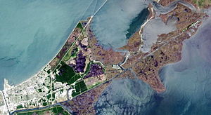
A notable characteristic of New Orleans East is its abundance of green spaces, including Bayou Sauvage Urban National Wildlife Refuge, Audubon Louisiana Nature Center, and Joe W. Brown Park.
[1] Other developments in the 1800s were the construction of the forerunner to Chef Menteur Highway in Village de L’Est and a sugar cane plantation and refinery in Venetian Isles.
The other older area of development consisted of a linear strip of "camps", clusters of houses raised high on wooden stilts, in the shallows along the edge of Lake Pontchartrain, the largest and longest-lasting of these being at Little Woods.
Construction of the Industrial Canal began in 1918 and was completed in 1923, creating the principal geographical barrier that would separate eastern New Orleans from the rest of city.
Eastern New Orleans' present southern boundary was realized in 1944 with the completion of a re-routing of the Intracoastal Waterway, involving the excavation of a new segment stretching east from the Industrial Canal to the Rigolets, cut through the raw swampland south of the Gentilly Ridge and north of Bayou Bienvenue.
Some care was taken to avoid placing major thoroughfares along the rights-of-way of unsightly drainage canals, as had frequently occurred in suburban Jefferson Parish.
Numerous subdivisions were developed with large lakes at their centers, providing both an assist to neighborhood drainage and a scenic backdrop for the backyards of homes.
By 1980, the area had also received significant commercial office and retail investment, epitomized by the regional mall The Plaza at Lake Forest, the largest in Greater New Orleans at the time of its completion in 1974.
More importantly, in the wake of the 1986 Oil Bust significant poverty was introduced into eastern New Orleans, as many of the sprawling garden apartment complexes built in the 1960s and 1970s along I-10 to house upwardly mobile young singles began to accept large, poor, female-headed households as tenants.
This "new-town-in-town" was to have resembled Reston, Virginia or the Woodlands north of Houston, but only a few small portions were built in several bursts of activity in the twenty years prior to the Oil Bust.
The prominent "New Orleans East" cast-concrete sign just west of the Michoud Boulevard exit was fabricated circa 1980 during the final attempt at developing this huge tract.
This attempt got as far as recommending a specific runway configuration and site in eastern New Orleans; a man-made island was to be created south of I-10 and north of U.S. Route 90 in a bay of Lake Pontchartrain.
As of January 2007, still less than half of the pre-Katrina residential population had returned, and many were living in FEMA trailers as they gutted and repaired their flood-devastated homes.
The returning population was more affluent: determined to permanently reduce the neighborhood's quantity of multi-family housing, eastern New Orleans homeowners lobbied against many rental developments proposed in the post-Katrina era.
This commercial node, largely populated by family-owned businesses, is now enjoying the long-awaited return of national retailers, with Big Lots and Wal-Mart leading the way.
Consistent with eastern New Orleans' eve-of-Katrina concentration of African-American entrepreneurship, black-owned franchises, such as the USA Neighborhood Market, have also appeared.
Efforts to secure high-quality private investment on the site of the former Plaza regional mall continue, and the city in late 2020 issued a Request For Proposals ("RFP") addressing the shuttered Six Flags/Jazzland amusement park, located prominently at the intersection of I-10 and I-510.
The amusement park was closed as a precautionary measure in advance of Hurricane Katrina's landfall, but Six Flags opted not to re-open it, post-Katrina.
Within the developed portion, numerous distinct neighborhoods may be found, including Pines Village, Plum Orchard, West Lake Forest, Read Boulevard West, Little Woods, Read Boulevard East, Village de L’Est, Lake Catherine and Venetian Isles.
[1] Pines Village, the area closest to Chef Menteur Highway and the Industrial Canal was one of the first neighborhoods to be developed in eastern New Orleans.
[2] Developing the neighborhood included leveeing the marshy area and lowering the water table by pumping, raising the level of construction sites by use of hydraulic fill and finally, building a drainage system consisting of a series of lakes and canals.
[dubious – discuss] By the late 1990s, the neighborhoods of Read Blvd East were no longer majority white, but were particularly favored as the preferred place of residence for New Orleans' upwardly mobile African-American white-collar professional and entrepreneurial classes.
On the corner of Dwyer Blvd and Willowbrook Dr. is the Mary Queen of Vietnam Church which serves as at hub for Vietnamese people whether christian or not to celebrate community and bring unity within the children and families all around.