Newcastle town wall
By the mid-18th century the wall had become obsolete and, as the town was redeveloped, large sections were demolished leaving only parts standing.
At that time there was a power struggle between England and Scotland, that eventually led to the Wars of Scottish Independence.
The Scottish kings were always ready to take advantage of any weakness in English rule to invade the North of England.
An example of this is David I of Scotland, who took advantage of the civil war between Stephen and Matilda to invade Northumberland in three successive years—1136–8.
[1] A special tax, or "murage", was levied by the borough to pay for the construction, murus being Latin for wall.
Here, the wall was pierced by a number of water gates that allowed access to the river for loading and unloading of ships.
The postern gates were provided for institutions, such as the Dominican Order of Blackfriars and the Hospital of St Mary the Virgin (which still exists as an almshouse charity), so that they could access their property outside the walls.
As the border wars between England and Scotland became less frequent, and in particular following the union of the two crowns in 1603, the wall was allowed to deteriorate.
[9] A long decline then began, during which the wall was demolished piecemeal to make way for new developments and to create better access to the town centre.
[10] The first part of the wall to be demolished was the stretch on the quayside, as it was regarded as "a very great obstacle to carriages and a hindrance to the despatch of business".
In early times, Close was the principal residence of the wealthy traders of the town, and was lined with merchants’ houses backing on to the river, with their own wharves.
It is believed that the town wall ran only a short distance eastwards along the river from the Close Gate.
It had large oak gates and iron doors, and was described by the antiquary, John Leland, as "a mightye strong thinge."
[10] Large amounts of the wall were demolished during the 18th and 19th centuries; the most substantial remains are on the western side of the city.
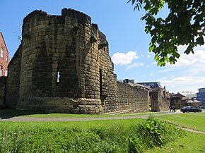
The longest continuous section runs the length of Back Stowell Street, in the Chinatown area.
[16] At the northern end of this section, the wall has been cut through by St Andrew's Street, with fragmentary remains in St Andrew's churchyard, opposite; at the southern end, Stowell Street cuts through onto Bath Lane.
[17] From Stowell Street, a complete section of wall, which includes Durham Tower, stretches southeast along Bath Lane, ending close to Westgate Road.
Near the river, a partially demolished section of wall is visible on the steep bank between Hanover Street and Close which, between the 1840s and the 1980s, was covered by warehouses.