Niamey
[4] The city is located in a pearl millet growing region, while manufacturing industries include bricks, ceramic goods, cement, and weaving.
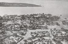
[citation needed] Probably, Niamey originated in the 18th century as a cluster of small villages (Gaweye, Kalley, Maourey, Zongo and Foulani Koira).
[5] Zinder's proximity to the Nigerian border and distance from French-controlled ports prompted the French to move the capital back to Niamey in 1926, by which time the city had some 3,000 inhabitants.
[5] Prior to 1926-27 the Upper Volta-Niger border ran along the Niger river, meaning that Niamey lay directly on the boundary.
[9] On April 9, 1999, Niger President Ibrahim Baré Maïnassara was ambushed, shot and killed during Nigerien coup d'état by soldiers, reportedly members of the Presidential Guard at the Diori Hamani International Airport as he was going to board a helicopter.
[11] The Niamey region straddles between the Liptako, corresponding to the northern extremity of the East ridge of Man, and the south-western edge of the Iullemmeden basin.
At Niamey, the river, running almost straight SSE from Gao, Mali, makes a series of wide bends.
[citation needed] The vast majority of the population and government and commercial buildings are located on the eastern bank of the river.
[citation needed] The climate is hot and semi-arid (Köppen climate classification BSh), with an expected rainfall of between 500 mm (20 in) and 750 mm (30 in) a year, mostly beginning with a few storms in May, then a transition to a rainy season, usually lasting from sometime in June to early September, when the rains taper off rather quickly.
[19] The growing freedoms of the late 1980s and 1990s, along with the Tuareg Rebellion of the 1990s and famine in the 2000s, have reinforced this process of internal migration, with large informal settlements appearing on the outskirts of the city.
[19] In the 1990s, the capital district population growth rate was lower than the torrid national rate, suggesting large rural migration (urbanization) was negligible in Niger, there is an undercount, and/or the government's forced urban to rural deportations were effective.
[citation needed] The Mahatma Gandhi International Conference Centre (MGICC) was built in Niamey jointly by India and Niger.
Niger being a predominantly Muslim country, mosques are the most common places of worship, with the Grande Mosquée being the largest in the city.
In July 2011, the first Mayor under the new system, Oumarou Dogari Moumouni, was installed by the Governor of the CUN Mrs. Aïchatou Boulama Kané and the City Council.
[2] Under this devolution process[21] formalised in the 1999 Constitution of Niger, the CUN contains five urban communes, which are further divided into 99 quarters ("Quartiers") with elected boards.
[23] Niamey is served by the Diori Hamani International Airport, located 12 km southeast of the city, and is crossed by the RN1 highway.