Cameroon–Nigeria border
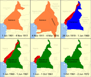
[2] In 1900 the administration of these areas was transferred to the British government, with the Northern and Southern (including Lagos and Calabar) protectorates united as the colony of Nigeria in 1914.
[3][2] The Scramble culminated in the Berlin Conference of 1884, in which the European nations concerned agreed upon their respective territorial claims and the rules of engagements going forward.
In April–June 1885 Britain and Germany signed a treaty outlining a border in the southern areas of Nigeria and Cameroon utilising the Rio del Rey and the Cross River.
[3][2] As the movement for decolonisation grew in the post-Second World War era, Britain and France gradually granted more political rights and representation for their African colonies.
[6][7][3] In 1994 a long-simmering dispute over the ownership of the Bakassi peninsula was forwarded to the International Court of Justice, ruling that the territory belonged to Cameroon in 2002.
Nigeria agrees not to refer the matter to the International Court of Justice to resolve the last remaining disputed border points.