Ningxia
[7] Ningxia is bounded by Shaanxi to the east, Gansu to the south and west and Inner Mongolia Autonomous Region to the north and has an area of around 66,400 square kilometres (25,600 sq mi).
[1] This sparsely settled, mostly desert region lies partially on the Loess Plateau and in the vast plain of the Yellow River and features the Great Wall of China along its northeastern boundary.
Over about 2000 years, an extensive system of canals (with a total length of approximately 1397 kilometers)[8] has been built from Qin dynasty.
The arid region of Xihaigu, which covers large parts of the province, suffers from severe water shortage, which the canals were intended to alleviate.
Before the arrival of viticulture, Ningxia's 6.8 million people, 36 per cent of whom are Muslims from the Hui ethnic group, relied largely on animal grazing, subsistence agriculture and the cultivation of wolfberries used in traditional Chinese medicine.
Since then, winemaking has become the premier specialty of Ningxia, and the province devotes almost 40,000 hectares to vineyards and producing 120 million bottles of wine in 2017 – a quarter of the entire nation's production.
The earliest human activity in Ningxia can be traced back to 30,000 years ago, with remains of the Shuidonggou Culture found in Lingwu.
[12]As a frontier zone between nomadic pastoralists and sedentary farmers, Ningxia was a frequent seat of war and incursions by non-Chinese tribes.
In 1934, warlord and National Revolutionary Army general Sun Dianying attempted to conquer the province, but was defeated by an alliance led by the Ma clique.
Among the artifacts were a white marble tablet from the Tang dynasty, gold nails, and bands made out of metal.
It was not until after Ma Hongkui died that his wife went to Taiwan in 1971 from America to bring the artifacts to Chiang Kai-shek, who turned them over to the Taipei National Palace Museum.
[17] Present-day Ningxia is one of the nation's smallest provincial-level units and borders the provinces of Shaanxi and Gansu and the Inner Mongolia Autonomous Region.
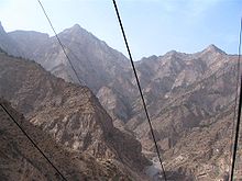
[18] Ningxia is a relatively dry, desert-like region and features a diverse geography of forested mountains and hills, table lands, deserts, flood plains and basins cut through by the Yellow River.
The grasslands are spread over the dry desert-steppe area in the northeast (which forms a part of the Inner Mongolian steppe region), and the hilly pastures located on the semi-arid Loess Plateau in the south.
[22] The ban stipulates that animal husbandry be limited to enclosed pens and no open grazing be permitted in certain time periods set by the Autonomous Region's People's Government.
Coal deposits are spread over one-third of the total surface of Ningxia, and mined in four major fields in the Helan and Xiangshan mountains, Ningdong and Yuanzhou (or Guyuan).
The Hejiakouzi deposit in Tongxin County features a reserve of 20 million tons of gypsum with a total thickness of 100 meters.
[citation needed] The Chairman of the Autonomous Region is the highest-ranking official in the People's Government of Ningxia.
Rural Ningxia was for long an officially designated poverty area, and remains on the lower rungs of the developmental ladder.
The Chinese authorities have given approval to the development of the eastern base of the Helan Mountains as an area suitable for wine production.
In addition, the major oil company China Petroleum and Chemical Corporation has founded a grape plantation near the Helan Mountains.
[55] One of Ningxia's main tourist spots is the internationally renowned Xixia Tombs site located 30 km (19 mi) west of Yinchuan.
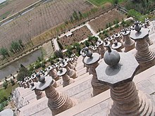
Other famous sites in Ningxia include the Helan Mountains, the mysterious 108 stupas, the twin pagodas of Baisikou and the desert research outpost at Shapotou.