Niobrara River
It then flows southeast across the Pine Ridge country of Sioux County, then east through Agate Fossil Beds National Monument, past Marsland, and through Box Butte Reservoir.
In north-central Nebraska it is joined by the Keya Paha River approximately 6 miles (10 km) west of Butte.
The river joins the Missouri northwest of Niobrara in northern Knox County, just upstream of Lewis and Clark Lake.
Although the annual runoff is low relative to the size of its drainage basin, the Niobrara has a stronger and more consistent flow than many other streams in the region.
[6] The Niobrara's average discharge between 1958 and 2013, measured at the U.S. Geological Survey stream gage at Verdel, Nebraska, 14.8 miles (23.8 km) above the mouth, is 1,757 cubic feet per second (49.8 m3/s).
Between 1861 and 1882, the stretch of the Niobrara River from the mouth of the Keya Paha to its confluence with the Missouri marked the boundary between Nebraska and the Dakota Territory.
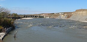
Located in Dawes County in western Nebraska, the dam is part of the Mirage Flats Project, which irrigates 11,670 acres (4,720 ha) on the north side of the Niobrara River.
[9] The Snake River tributary is impounded by the Merritt Dam and irrigates about 34,540 acres (13,980 ha) in the area of Valentine, Nebraska.