Geothermal areas of Yellowstone
Thus flat-bottomed valleys between ancient lava flows and glacial moraines are where most of the large geothermal areas are located.
Smaller geothermal areas can be found where fault lines reach the surface, in places along the circular fracture zone around the caldera, and at the base of slopes that collect excess groundwater.
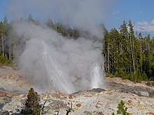
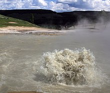
[5] The water cools significantly while airborne and is no longer scalding hot by the time it strikes the ground, nearby boardwalks, or even spectators.
Prehistoric Native American artifacts have been found at Mammoth Hot Springs and other geothermal areas in Yellowstone.
In the 19th century Father Pierre-Jean De Smet reported that natives he interviewed thought that geyser eruptions were "the result of combat between the infernal spirits".
Local natives that they came upon seldom dared to enter what we now know is the caldera because of frequent loud noises that sounded like thunder and the belief that the spirits that possessed the area did not like human intrusion into their realm.
[7] The first white man known to travel into the caldera and see the geothermal features was John Colter, who had left the Lewis and Clark Expedition.
Beaver trapper Joseph Meek recounted in 1830 that the steam rising from the various geyser basins reminded him of smoke coming from industrial smokestacks on a cold winter morning in Pittsburgh, Pennsylvania.
[3] The heat that drives geothermal activity in the Yellowstone area comes from brine (salty water) that is 1.5–3 miles (7,900–15,800 ft; 2,400–4,800 m) below the surface.
[9] Convection of the churning brine and conduction from surrounding rock transfers heat to an overlaying layer of fresh groundwater.
Movement of the two liquids is facilitated by the highly fractured and porous nature of the rocks under the Yellowstone Plateau.
Norris Geyser Basin is so hot and dynamic because these two faults intersect with the ring fracture zone that resulted from the creation of the Yellowstone Caldera of 640,000 years ago.
The Ragged Hills that lie between Back Basin and One Hundred Springs Plain are thermally altered glacial kames.
As glaciers receded the underlying thermal features began to express themselves once again, melting remnants of the ice and causing masses of debris to be dumped.
Madison lies within the eroded stream channels cut through lava flows formed after the caldera eruption.
Artists' Paintpots is a small hydrothermal area south of Norris Junction that includes colorful hot springs and two large mudpots.
Scientists hypothesize that this basin's structures formed from a hot water system in a glacially dammed lake during the waning stages of the Pinedale Glaciation.
Many landforms, such as Porcupine Hills north of Fountain Flats, are made up of glacial gravel and are reminders that 70,000 to 14,000 years ago, this area was buried under ice.
[14] Signs of the forces of erosion can be seen everywhere, from runoff channels carved across the sinter in the geyser basins to the drainage created by the Firehole River.
Despite its small size, it contains two large features, the 200-by-300-foot-wide (60 by 90 m) Excelsior Geyser which pours over 4,000 U.S. gallons (15,000 L; 3,300 imp gal) per minute into the Firehole River.
[17] Due to its large size, it has a much less concentrated set of geothermal features, including Fountain Paint Pots.
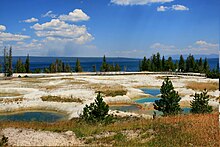
West Thumb was created approximately 162,000 years ago when a magma chamber bulged up under the surface of the earth and subsequently cracked it along ring fracture zones.
Walter Trumbull of the 1870 Washburn-Langford-Doane Expedition described a unique event while a man was fishing adjacent to the cone: "...in swinging a trout ashore, it accidentally got off the hook and fell into the spring.
As falling into geothermal features can be fatal, it is usually advisable to visit these areas with an experienced guide or at the very least, travelers need to ensure they remain on well-marked trails.
This makes water from the springs so acidic that it has dissolved holes in the pants of people who sit on wet ground and causes mounds of sulfur three feet (1 m) high to develop around fumaroles.
[25] It was created over thousands of years as hot water from the spring cooled and deposited calcium carbonate (over two tons flow into Mammoth each day in a solution).
[26] Although these springs lie outside the caldera boundary, their energy has been attributed to the same magmatic system that fuels other Yellowstone geothermal areas.
Because no water washes away the acid or leached rock, it remains as sticky clay to form a mud pot.