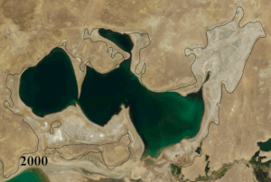
North Aral Sea
It split from the South Aral Sea in 1987–1988[2] as water levels dropped due to river diversion for agriculture.
In 1925 a large site containing numerous fossils of the Oligocene was discovered near the village of Akespe by the northern shore of the Aral Sea.
After the fall of the Soviet Union, the government of independent Kazakhstan decided to restore the northern lake fed by Syr Darya.
[6] The poorly built Dike Kokaral intended to contain the North Aral Sea and save its fisheries failed twice, but in 2005, the government of Kazakhstan was able to fund a more robust design.
Another project would be the construction of a second dam further north, halfway between Kokaral and Aralsk, this city would thus regain its maritime space.


1= Syr-Daria
2= Raised Dike Kokaral
3= Control of the Saryshyganak Bay
4= Shevchenko Bay exit control
5= Emissary from the Small Aral Sea to the Western Aral Basin
A= Shevchenko bay
B= Butakov bay
C= Saryshyganak bay
D= Barsakelmes Lake
E= Western Aral Sea basin.

1= Syr Daria
2= Saryshyganak Basin Feeder Channel
3= Existing Dike Kokaral
4= High Dam
A= Shevchenko bay
B= Butakov bay
C= Saryshyganak bay
D= Kamyslybas .