North Cascades National Park
The park has one of the earliest and longest lasting research programs dedicated to studying climate change, primarily through examining the effects of glacial retreat.
Human history in North Cascades National Park and the surrounding region begins 8–10,000 years ago, after the end of the last glacial period.
[5] Tools such as microblades made from Hozomeen chert are part of the archaeological record throughout the Skagit River Valley, west of the park and in regions to the east.
[9] The Skagits were generally lowlanders, who only ventured into the North Cascades during the summer months, and structures in the mountains were more modest, consisting mostly of temporary buildings erected with poles and covered with branches.
By the beginning of the 20th century, inland tribes, like their coastal neighbors, had experienced population decline from their first contact with white explorers a hundred years earlier, mostly due to smallpox and other diseases.
To the southeast of the modern park boundary, Ross and other members of the company constructed Fort Okanogan in 1811, as a base from which to operate during the early period of the Pacific Northwest fur trade.
[13] During the late 1850s, members of the US North West Boundary Commission explored the border region, attempting to identify which mountains, rivers and lakes belonged to which country.
[14] In 1882, US Army Lieutenant Henry Hubbard Pierce led a government-sponsored exploration that traversed the western boundary of the southern section of the current park, in search of transportation routes and natural resources.
[22] Washingtonians submitted a petition in 1892 to establish a national park to the north of Lake Chelan, as many who had visited the region believed it to have scenery "greater than Switzerland's".
[23] Further efforts took place in 1906, and again between 1916 and 1921, when artist Julian Itter and the Mazamas Alpine Club lobbied for a bill to designate "Mount Baker National Park".
[23] President John F. Kennedy directed the Departments of Agriculture and the Interior to fund a joint study into a possible national park in the North Cascades region, which was completed in January 1966 and submitted to Congress.
The northern boundary of the north district is also the international border between the United States and Canada; the latter manages adjoining Chilliwack Lake and Skagit Valley Provincial Park.
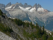
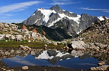
[51] Continued rising in conjunction with erosion from water and ice has created deep valleys and significant vertical relief that is comparable to much taller mountain ranges.
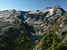
The streams at higher elevation are often directly supplied by meltwater from glaciers, and they carry finely ground rock particles commonly referred to as glacial flour.
[74] The dense concentration and relative ease of access to the North Cascade glaciers brought about some of the earliest series of scientific studies regarding glaciology in the United States.
Beginning in 1955, the University of Washington sponsored Richard C. Hubley to undertake annual aerial photography expeditions designed to capture images of the glaciers and to show any alterations that might be occurring.
[74] At the time of Austin Post's inventory, their study concluded that some North Cascades glaciers had experienced a period of minor growth or equilibrium in the mid-20th century, after undergoing decades of retreat.
The study concluded that annual glacial melt due to seasonal variations has a significant influence on river levels, accounting for about 30 percent of the late summer water flow, which directly impacted the supported ecosystems such as salmon fisheries.
Geographical features in the area can be found in this clickable map:Eight distinctive life zones support thousands of different plant and animal species in the North Cascades National Park ecosystem.
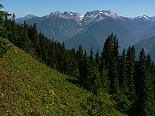
[81][82] The flora in North Cascades National Park is influenced by the great vertical relief, the amount of moisture an area receives, the slope and soil types as well as the fire ecology.
These species are heavily dependent on deep soils, and red cedars 1,000 years old and over 200 ft (61 m) tall can be found on Big Beaver Creek.
A total of 18 species of carnivores including coyote, bobcat, lynx, cougar, mink, river otter and black bear have been reported within this park.
[99] They are seldom sighted in the park, both due to the limited numbers of the species and the habitats they prefer, which are snowy high-altitude regions far removed from human encroachment.
Reptiles such as the northern alligator lizard and the common garter snake and amphibians such as the western toad, Pacific giant salamander and rough-skinned newt reside in the park.
[109][107] In North Cascades National Park, fire was used by Native Americans in the region near present-day Ross Lake to clear out brush, to ease foot travel, and possibly to flush animals out of the foliage.
[110]: 36 North Cascades National Park has a condition type that shows "...natural (historical) range of variability of vegetation characteristics; fuel composition; fire frequency, severity and pattern; and other associated disturbances.
"[110]: 22 This condition type, in keeping with the wilderness designation applied to most of the park, equates to a natural "let it burn" policy overall, so long as people and historical property are not threatened and the fire was lightning-caused.
[117] The industrialized regions around Puget Sound and the Fraser River Valley have had a more noticeable negative impact on water and air quality than at Mount Rainier National Park well to the south due to the prevailing winds.
Sulfur, nitrogen dioxide and ozone from factories and automobile emissions as well as increased dust and fine particulates from sources such as farming and construction are dispersed into the atmosphere, reducing long-range visibility.
[133] North Cascades National Park’s rugged terrain and limited access to drivable campgrounds make it particularly dangerous for inexperienced campers and hikers.