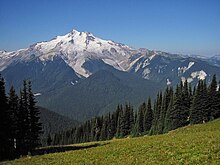
Glacier Peak
Glacier Peak or Dakobed (known in the Sauk-Suiattle dialect of the Lushootseed language as "Tda-ko-buh-ba" or "Takobia"[5]) is the most isolated of the five major stratovolcanoes (composite volcanoes) of the Cascade Volcanic Arc in the U.S state of Washington.
Local Native Americans have recognized Glacier Peak and other Washington volcanoes in their histories and stories.
When American explorers reached the region, they learned basic information about surrounding landforms, but did not initially understand that Glacier Peak was a volcano.
The volcano formed during the Pleistocene epoch, about one million years ago, and since the most recent ice age, it has produced some of the largest and most explosive eruptions in the state.
Past pyroclastic flow deposits are easily visible in river valleys near the volcano, likely caused by lava dome collapse, along with ridges found east of the summit consisting of ash cloud remains.
[6] On its western flank, the volcano also has a lahar, or mudflow deposit, which runs for about 22 miles (35 km) into the White Chuck River Valley around 14,000 years ago.
Another lahar, of unidentified age, was rich in oxyhornblende dacite; and continued for 30 km (19 mi) into the Sauk River.
Studies of the mountain have to date been unable to find any correspondence with pyroclastic flows, but several past mudflows have been identified.
In the Dusty Creek valley, which runs east from the mountain, there is a lahar at least 98 ft (30 m) thick, containing pyroclastic flow deposits and other mudflows.
[7] On the mountain, about 5,900 ft (1,800 m) up, are three additional cinder cones — one at the head of White Chuck River, one at Dishpan Gap, and one near Indian Pass.
[13] Another Cascade Arc volcano with similar geomorphology is the Mount Meager massif in southwestern British Columbia, Canada, which is situated on a 1,300 ft (400 m) ridge of nonvolcanic, crystalline and metamorphic rock.
[14] Of the five major volcanoes in Washington, only Glacier Peak and Mount St. Helens have had large eruptions in the past 15,000 years.
Gradually, the pressure grows, culminating in an explosion that ejects materials such as tephra, which in its simplest form, is ash.
Mixed with snow, ice and water, these formed lahars that raced into three nearby rivers, filling their valleys with deep deposits.
Lahars from Glacier Peak pose a similar threat to the small communities of Darrington, Arlington, and Concrete with a lesser threat to the larger and rapidly growing towns of Mount Vernon and Burlington, as well as other communities along the lower Skagit and Stillaguamish Rivers.
[20] In 2018, the USGS applied to add four more stations, but regulations protecting federal wilderness areas prohibit the use of helicopters that are needed to transport materials; advocacy groups opposed an exemption for the project and filed objections.
Richard Hubley noted that North Cascade glaciers began to advance in the early 1950s, after 30 years of rapid retreat.
The Suiattle River crossing is a well-known feature on the Pacific Crest Trail (PCT) as it passes through the area.
[27] The first recorded person to climb the mountain was Thomas Gerdine, along with a group of United States Geological Survey scientists, Sam Strom, A. H. Dubor, and Darcy Bard, in 1897.
The non-fiction book Encounters with the Archdruid by John McPhee, which portrays the environmental advocacy of David Brower, devotes the first of its three main sections to a conflict over mineral prospecting around Glacier Peak.