North Laclo River
[2][3][5] The two rivers are not connected to each other; both rise in the uplands near Turiscai in Manufahi municipality, where a drainage divide causes them to flow northwards and southwards, respectively, in each case later augmented by several tributaries.
[15] It replaced an earlier bridge that had been funded by the Australian aid program, built by Indonesian public works engineers, and opened in 1984.
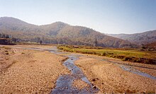
[14]: 6–7 During the rainy season, the middle and lower reaches of the river have increased sedimentation rates, due to flash flooding, which, typically, causes the otherwise braided channel to become submerged.
When flooded, the river carries abundant sediments from parent rock in the upper catchment, and deposits them in the channel and on the floodplain.
[9]: 15 The river then runs freely through its mouth, and large flows create turbid plumes that head eastwards along Wetar Strait.
[8]: LM, F-7 Excluding the portion downstream of the Laclo irrigation system's intake, the catchment is around 1,386 km2 (535 sq mi) or 138,600 ha (342,000 acres) in area, with the eight tributaries.
[8]: S-1, S-4 [14]: 38 Timor-Leste has been broadly divided into twelve 'hydrologic units', groupings of climatologically and physiographically similar and adjacent river catchments.
[14]: 5 In April 2005, the Ministry of Agriculture, Fisheries, and Forestry appointed the Japan International Cooperation Agency (JICA) to develop a community-based integrated watershed management plan for the Laclo and Comoro River catchments.
[8]: S-1 [14]: 6 The deforestation, in turn, caused tributaries in the upper reaches of the catchment to become intermittent, and is believed by local people to have led to the drying up of springs in those uplands.
[14]: 12, 15 [32]: 15, 22 The catchment was also disturbed by cultivation, shifting agriculture, construction of roads, villages and towns,[14]: 25 and Indonesian transmigration and relocation policies.
In some parts of the catchment, burning was still used to flush out game for hunting, but in other areas, it was banned, in compliance with local Tara Bandu [de] rules.
The two forms of erosion, in turn, had combined to increase flooding in the river, and, by making its channels wider and braided, had caused its flows to become more erratic.
[32]: 5 Another factor in the erosion of the catchment is that Timor is the deformed northern margin of the Australian continent, where Australia is colliding with the Banda Arc.
[14]: 16 In 2010, landslides/slope failures in the catchment were reported to be concentrated in the upper part of Ue Coi, Sumasse, Eraibanaubere, Malikan and Lohun sub-catchments.
Phyllites are located in the catchment between the central mountains at an elevation of about 1,000 m (3,300 ft) AMSL and the river mouth at sea level.
[8]: S-6–S-7 [14]: 41 There are also limited areas of irrigated rice cultivation adjacent to the main channels of the river, mostly in its lower reaches between Laclo and Manatuto.
[14]: 41 The Sumasse River is the main provider of the water supply to the Laclo irrigation system, on the south and northwestern periphery of Manatuto city.
[34]: xi In December 2001, the Government of Japan decided to extend emergency assistance for a UNDP project to rehabilitate the system.
[34]: xi–xii According to a 2014 evaluation report of the scheme, frequent flooding during the rainy season had caused damage to the irrigation and related facilities, roads and paddy fields.
As in the rest of Timor-Leste, there is widespread reliance upon poultry and pigs, and herds of Bali banteng cattle, buffalo, sheep and goats.
More recently, such grazing has become difficult, because deforestation has promoted the growth of Siam weed (Chromolaena odorata), which is toxic to cattle and also suppresses other ground vegetation.
[7]: 5 [37]: E-24 The river water intake pipe was subject to erosion and damage, because it had been laid in a flood-prone riverbank in an area where sand mining activities took place.
[7]: 5, 29 Additionally, the transmission pipe from the pumping station to the reservoir passed through paddy fields, where it was at a high risk of being damaged by tractors and other agricultural equipment.
[32]: 5 The catchment has been assessed as having potential for the construction of a large scale multi-purpose dam to harvest raw water and generate hydroelectricity by hydropower.