Memphis Parkway System
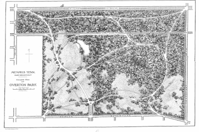
Planning and construction of the Lea's Woods tract of land (now known as Overton Park) was started in 1902 and completed in the same year.
[citation needed] The project had been delayed due to a lawsuit stating the government was using its power of eminent domain incorrectly, but the Tennessee Supreme Court found in favor of the city.
Instead of a winding system of meandering parkways, Kessler decided to create a rectangular border around the city of Memphis using some existing streets.
Kessler originally designed parts of the Parkway System to be straight portions of tree-lined avenues where car and carriage owners could race against each other.
However, the city of Memphis ended this practice in 1910 and imposed a speed limit on the entire system.
Today, the road's racing past can still be seen in the name of the Speedway Terrace Historical District along North Parkway near Watkins Street.
Many cities in Tennessee used Memphis' park and parkway system as a model for their own urban planning.
[2][3] Moving in a counter-clockwise direction from the southwest corner, the Parkway System starts at Martin Luther King Jr. Riverside Park.
This portion, known as South Parkway West, is a four-lane undivided road through an industrial area with no boulevard median or landscaping.