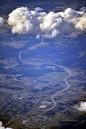
North Spokane Corridor
The project is being managed by the Washington State Department of Transportation (WSDOT) and will ultimately create a freeway with a speed limit of 60 mph (97 km/h) along a new alignment linking Interstate 90 (I-90), to the existing US Route 395 (US 395) 10.5 miles (16.9 km) to the north in the Wandermere area.
When completed, the multi-modal facility is expected to have general travel lanes, with right-of-way reserved for a future high-capacity transit system with park-and-ride lots.
After 33 years of further discussions and proposals, the final environmental impact statement (FEIS) for the current version of the project was approved in April 1997.
[6] The first ribbon cutting ceremony (for a 3.5-mile (5.6 km) segment of lanes between the Francis/Freya and Farwell interchanges) occurred on the eighth anniversary of the ground breaking, August 22, 2009.
[12] In June 2012, WSDOT received TIGER Grant funding for the next project, which includes further construction of the Children of the Sun Trail into Hillyard, plus realignment of the railroad mainline and spur under the new structure.
In July 2015, the Connecting Washington transportation package was signed by Governor Jay Inslee, bringing $879 million in state funding for the completion of the North Spokane Corridor project.
[13][14] Construction on the southern half began in early 2017 with work on the Freya Street overpass and is the whole project is anticipated to be completed by 2027 or 2029, depending on funding.
[8][15][16][17] Grading and paving of a section between Freya Street and Central Avenue was completed in September 2019, but remains closed to traffic.
[18] In October 2019, the second realignment of the BNSF Railway tracks began to make way of further construction of the NSC; one month later, Wellesley Avenue was closed off to traffic.
[19][20] The section between Freya Street and Wellesley Avenue was opened to northbound traffic on November 16, 2023, extending the freeway by 1.5 miles (2.4 km) and into the city limits of Spokane.
[21][22] In 2023, WSDOT requested public feedback on two potential designs for the I-90 interchange (the final segment of the North Spokane Corridor) at the future southern terminus of the NSC.
The community chose this option due to it having a smaller infrastructure footprint with greater potential for placing pedestrian bridges for future development.
By moving cars from congested streets to a freeway, WSDOT predicts that it will reduce auto emissions by 3.6% annually and save a million gallons of fuel a year.
[25] A 1997 report by WSDOT noted that the construction of the southern portion of the freeway will require the demolition of over 500 homes and 100 business, necessitating the relocation of over 1,000 residents.
[28] The completion of I-90 resulted in growth in eastern suburbs that were once small towns, while many neighborhoods in the center of the city experienced poverty and decline.
[28] The environmental impact statement predicted more development in Pend Oreille County and Deer Park north of the city.