Nullarbor Plain
It is the world's largest single exposure of limestone bedrock, and occupies an area of about 200,000 square kilometres (77,000 sq mi).
[5][6] The first Europeans known to have sighted and mapped the Nullarbor coast were Captain François Thijssen and Councillor of the Indies, Pieter Nuyts, on the Dutch East Indiaman 't Gulden Zeepaert (the Golden Seahorse).
In writing about Eyre's voyages in 1865, Henry Kingsley wrote that the area across the Nullarbor and Great Australian Bight was a "hideous anomaly, a blot on the face of Nature, the sort of place one gets into in bad dreams".
[10] Eyre departed westwards from Fowlers Bay, South Australia on 17 November 1840 with John Baxter and a party of three Aboriginal men.
Eyre and the third Aboriginal man, Wylie, continued on their journey, surviving through bushcraft and some fortuitous circumstances such as receiving some supplies from a French whaling vessel anchored at Rossiter Bay, Western Australia, some 36 kilometres (22 mi) east of Esperance.
[11] A proposed new state of Auralia (meaning "land of gold") would have comprised the Goldfields, the western portion of the Nullarbor Plain and the port town of Esperance.
[12] An older property is Madura Station, situated closer to the coast; it has a size of 1.7 million acres (690,000 ha) and is also stocked with sheep.
[15] The Nullarbor Plain is a former shallow seabed, as indicated by the presence of bryozoans, foraminifera, echinoids and red algae calcareous skeletons that make up the limestone.
[16][18] The sequence within the limestone includes five formations: One theory is that the whole area was uplifted by crustal movements in the Miocene, and since then, erosion by wind and rain has reduced its thickness.
[16] According to Curtin University research published in 2023, "Nullarbor drastically shifted to dry conditions between 2.4 and 2.7 million years ago".
This original line suffered severe problems with track flexing and settling in the desert sands, and journeys across the Plain were slow and arduous.
It services the numerous cattle and sheep stations that populate the Western side of the Nullarbor and affords access to rail maintenance teams.
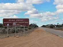
Stickers bought from roadhouses on the highway show "I have crossed the Nullarbor", and can be seen on vehicles of varying quality or capacity for long-distance travel.
The process of "beating the crowds" on overbooked and overpriced air services at the time of special sporting events can also see significant numbers of vehicles on the road.
Crossing the Nullarbor in the 1950s and earlier was a significant achievement, as most of the route then was a dirt track of variable quality, and presenting real hazards to the motorist.
[37] On 25 December 1896, after an arduous journey of thirty-one days, Arthur Charles Jeston Richardson became the first cyclist to cross the Nullarbor Plain, pedaling his bicycle from Coolgardie to Adelaide.
[39] In 1937 Hubert Opperman set a record fastest time of 13 days, 10 hours and 11 minutes for the transcontinental crossing from Fremantle to Sydney.
[41] Between 29 June and 3 July 2015, brothers Tyron and Aaron Bicknell recorded the fastest-known crossing of the Nullarbor Plain on single speed bicycles.
[42][43] In January 2017, Austrian cyclist Christoph Strasser set the current record from Norseman to Ceduna of 1 day, 21 hours, 42 minutes.
[44] The first non-Indigenous person to walk across Australia from the west to the east coast, Henri Gilbert, crossed the Nullarbor Plain on foot, with no support team or stock, in the middle of summer.
[45] For two winter months in 1985, six young Jesus Christians walked 1600 kilometres (1000 miles) from Port Augusta to Norseman without taking any food, water, additional clothing or a support vehicle- although supplies were given to them by passing motorists.
[46] In 1998, runner Robert Garside ran across the Nullarbor without a formal support crew, as part of an authenticated run around the world.