Eyre Highway
Continuing to the South Australian town of Ceduna, it crosses the top of the Eyre Peninsula before reaching Port Augusta.
A national highway was called for, with the federal government seeing the route's importance in 1941, when a war in the Pacific seemed imminent.
It crosses the top of the Eyre Peninsula as it continues eastwards for 470 kilometres (290 mi), before reaching Port Augusta.
[5][6] The vast majority of the highway is a two-lane single carriageway[3] with a speed limit of 110 kilometres per hour (68 mph), except in and around built-up areas.
[12] The Eyre Peninsula has been extensively cleared for agriculture, although there are remnant corridors of native eucalyptus woodland alongside its roads.
[14]: 5 In South Australia, the estimated annual average daily traffic as of September 2015 varied between 500 and 1,500 vehicles west of Lincoln Highway, and was 2,700 to the east.
The individual risk based on casualty crash rates per vehicle kilometre travelled was assessed as high for the 95 km section east of Yalata to Fowlers Bay.
[22] Because of its remoteness, some widened sections of the highway serve as emergency airstrips for the Royal Flying Doctor Service.
[23] These airstrips are signposted, have runway pavement markings painted on the road, and turnaround bays for small aircraft.
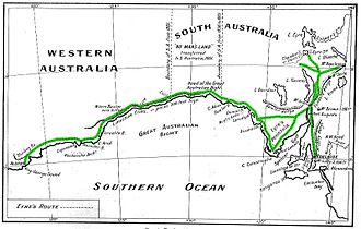
[25] In 1840–1841, Edward John Eyre was the first European to traverse the coastline of the Great Australian Bight and the Nullarbor Plain by land, on an almost 2,000-mile (3,200 km) trip from Adelaide to Albany, Western Australia.
They would cause a nuisance for station owners and other travellers by scrounging petrol, contaminating water supplies, leaving gates open, and committing acts of vandalism.
[39] A northerly route, close to the Trans-Australian Railway, had been considered, but extensive limestone outcrops made it impractical.
[35]: 96 By the middle of the century, several water tanks with up to 44,000 imperial gallons (200,000 L; 53,000 US gal) capacity were located alongside the highway, including at Madura Pass, Moonera, Cocklebiddy, and 28 miles (45 km) east of Mundrabilla.
[45] In the 1930s and 1940s, the Western Australian Nomenclature Advisory Committee[c] had been choosing directional names for the state's main arterial roads, such as Great Eastern Highway.
[37] On 21 January 1942, Prime Minister John Curtin announced the war cabinet decision to name the newly constructed road Forrest Highway,[49] for military purposes.
[51] The South Australian section was named Eyre Highway on 20 May 1943, with the portion from Murat Bay (Ceduna) to the state border declared a main road.
The road received yearly maintenance, but further, more expensive works were not warranted due to the low traffic volume of approximately fourteen vehicles per day.
[35]: 186–7 When it did rain, even in small amounts, the road would become boggy, from patches that had broken down into a powdery substance, known as "bulldust", during dry periods.
[35]: 223 Large numbers of vehicles travelling the highway in 1962, for the Commonwealth Games in Perth, damaged the road in numerous locations, and the lack of moisture required salt water to be pumped from 350 feet (110 m) below the surface for use in repairs and maintenance.
With increased priority given to the project from 1966, Western Australia's portion of the highway was completed in 1969, with a ceremony held in Eucla on 17 October.
The final link to be sealed, between Penong and the state border, was completed with a ceremony held in September 1976 near Wigunda Tank, South Australia.
[56] The older route, Old Eyre Highway,[57] runs from Border Village to the Nullarbor Homestead, approximately 15 to 20 kilometres (9 to 12 mi) away from the coast.
Increasing numbers of truck and tourist coaches caused fretting, and reduced the actual sealed width to 5.6 metres (18 ft) along much of Eyre Highway.
Main Roads in Western Australia spent around a million dollars a year on rehabilitating 50-to-100-kilometre (30 to 60 mi) sections.
A major project to improve Eyre Highway, rather than just repair the damage, began in 1984 with federal government providing funding to reconstruct 300 kilometres (190 mi) in Western Australia.