Oak Island (North Carolina)
Both ends of Oak Island have extensive marshland, while its two major internal waterways (Davis Canal and Montgomery Slough) run east to west and drain into the Lockwood Folly River.
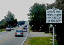
[10] By the 1930s the island had blossomed into a vacation resort as beach cottages began to dot the area on its western half, something which Hurricane Hazel brought a temporary halt to in 1954 as it washed away some 350 buildings on or near the ocean front.
[16] One such group, familiarly known as the Crabbies was a key player in the Brunswick County effort opposing seismic testing and off shore drilling as proposed the Bureau of Ocean Energy Management (BOEM).
Located on the east end of the island, in 2004 the Town of Caswell Beach acquired it and in 2007 it was added to the National Register of Historic Places.
[20] Summers on Oak Island are hot and humid with an average temperature of 85˚, although the beach front is cooled much of the time by sea breezes (the prevailing winds are from the southwest).
[21] Tropical storms are a continuing source of concern, e.g., in the 1996-1999 period, four major hurricanes (Bertha, Fran, Bonnie, and Floyd) made landfall and had significant effects on the area.
The Oak Island Golf course and its related practice facilities are open to the public and an outdoor swimming pool is available for its members' use during the summer.
The Oak Island Recreation Center located mid-island provides both indoor and outdoor exercise facilities and rents out sports equipment and amenities like balloon tire, beach wheelchairs.
[29] Monthly Civil War Roundtables are held at the Hatch Auditorium in the NC Baptist Assembly while the Oak Island Library hosts a wide variety of events to include "Socrates Cafe" and "Meet the Author" programs.