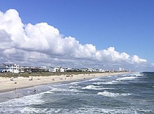
Pleasure Island (North Carolina)
Prior to the 1931 completion of a man-made canal called Snows Cut, the land that now forms Pleasure Island was part of a peninsula known as Federal Point, a long narrow strip of sandy ground that stretched from Myrtle Grove to Fort Fisher.
There are no roads between the two halves of the combined island, but park ranger vehicles, fat-tire bike riders and pedestrians can traverse the beach strand to make the connection as needed.
[3] The area that is now Pleasure Island has gone through a variety of changes over the last few hundred years to end up with its current shape, extending from the Carolina Beach Inlet to Cape Fear.
To protect access to the port, the United States Army Corps of Engineers built a 1-mile long stone dam, eventually known as "The Rocks", between Zeke's Island and the southern tip of Federal Point.
[6] After the building of the two rock dams, only smaller boats and skiffs could travel from the ocean into the meandering creeks behind Smith Island to access the Cape Fear River.
In 1930, Snows Cut was dug out (roughly along the line of the lower portion of Telfair Creek) connecting the Cape Fear River to Myrtle Grove Sound and officially turning the tip of the Federal Point peninsula into a barrier island.
Snows Cut was, and still is, an important part of the Intracoastal Waterway as it allows boats to avoid the treacherous Frying Pan Shoals, which extend some 30 miles into the ocean off Cape Fear.
Federal Point was historically home to small groups of Native Americans, but much heavier concentrations, perhaps numbering into the thousands, lived on the west side of the river or upstream.
England laid its European claim to the area that is now the eastern United States (including Federal Point) in 1497 after the first voyage of Venetian John Cabot, who was in the service of King Henry VII.
Several attempts at English colonization in the areas North and South of the Cape Fear region were launched during the ensuing century, notably the failed colony of Roanoke.
[9] In 1662, William Hilton Jr., an English captain raised in New England, sailed to the region on his ship Adventure in the service of Puritans from the "heavily-populated" Massachusetts Bay Colony.
Legend says the party left behind a sign on a tree near the bar at the mouth of the Cape Fear River warning others to not try to settle in the supposedly inhospitable area.
[1] In late 1663, Hilton accompanied another group of English colonists, this time from Barbados and led by John Vassall, who were hoping to settle in the area to escape the overcrowding on the booming eastern Caribbean Island.
[9] Disputes with the Charles Town settlers, Indian issues, lack of resupply, and other factors soon led Yeamans to head back to Barbados, leaving Vassall in charge.
[11] European Settlers slowly continued to arrived in the Carolina region which ultimately resulted in the Tuscarora War (1711–1715), which forced the Native Americans further west.
[1] He crossed near the Haulover at the Sugar Loaf (present day Carolina Beach State Park) and landed on the west side of the river at what would eventually become Brunswick Town.
Later that year, before the fort was finished, two Spanish ships sailed up the Cape Fear River and attacked Brunswick Town,[11] an act that was part of King George's War.
From the inception of Brunswick Town and Wilmington, dozens of large slave-holding plantations were quickly established, capitalizing on the vast lands and the low cost of overwater transport.
Around 1850, in the midst of the antebellum era, two "free colored persons" of mixed African and Native-American heritage, Alexander and Charity Freeman,[14] acquired 250 acres of swampy, sandy land on the lower portion of the Federal Point Peninsula near Myrtle Grove Sound.
The subsequent fall of the fort and the loss of Cape Fear River shipping greatly diminished the south's ability to prosecute the war and eventually helped lead to a cessation of fighting.
By the 1880s, entrepreneurs and promoters from the Wilmington area had their eye on the lower portion of Federal Point due to its easy access from the town (down the river by steamship) and the short distance across the island to the ocean.
In the early 1920s, descendants of Robert Freeman founded the African-American beach resort at Seabreeze (or Sea Breeze), on family lands now to the north of Snows Cut.
After a brief period of decline in the late twentieth century, Carolina beach is now flourishing with the addition of a refurbished boardwalk as well as many new restaurants, businesses and beachfront hotels.
In the early 1880s a Danish ship captain, named Hans Kure, moved his family from Charleston, SC to Carolina Beach, where he ran various businesses.
The Seabreeze resort area was created by the descendants of Alexander and Robert Freeman during the Jim crow era as a place where African-Americans could come enjoy the beach and nightly entertainment[21] without harassment.
In the years before the Snows Cut canal was built, Seabreeze vacationers on the mainland side could wade or swim across the shallow Myrtle Grove Sound and access Freeman Beach.
Today the sound side of Seabreeze is a coastal forest where trailers and smaller cottages mix with higher-end subdivisions and expensive sound-front houses.
During the American Civil War the Sugar Loaf was part of a fortification that was extended across the island to Myrtle Grove Sound[26] in order to block Union troop access up the Federal Point Road, which led directly to the vital Port of Wilmington.
The Fort Fisher portion of the island was home to various military installations between 1865 and 1988, including a World War II firing range and landing strip.
In addition to white-tailed deer, red fox, coyotes and assorted mammals, Pleasure Island is home to a wide variety of permanent and migrating species of birds, fish, and occasional wintertime whales.