Occitania (administrative region)
The banner of arms of the Counts of Toulouse, known colloquially as the Occitan cross, is used by the modern region and is also a popular cultural symbol.
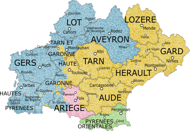
[12] It has a Mediterranean coast on the southeast and is neighboured by Provence-Alpes-Côte d'Azur on the east, Auvergne-Rhône-Alpes on the northeast and Nouvelle-Aquitaine on the west and northwest, as well as foreign borders of Andorra (Canillo, Encamp, La Massana, Ordino) and Spain (Aragon and Catalonia) on the south.
The largest communes of Occitania are (population as of 2017[update]):[13] The gross domestic product (GDP) of the region was 171.2 billion euros in 2018, accounting for 7.3% of French economic output.
The new administrative region includes provinces and territories of diverse cultural and historical origin: Languedoc (High and Low Languedoc), Països Catalans (Roussillon, Cerdanya, Vallespir, Conflent, Capcir), the County of Foix, and the eastern parts of what was formerly Gascony (Armagnac, Comminges, Couserans, Bigorre, Condomois, Nébouzan, Rivière-Verdun), and Guiana (Carcin, Roergue).
This territory was already united, in Roman times first as the Diocese of Vienne and then as the Seven Provinces (Septem Provinciae)[21] and in Aquitaine at the beginning of the Middle Ages[22] (Aquitanica, Visigoth kingdom of Toulouse),[23] before the Frankish conquest.
[26] Most of the territory that came to be called Languedoc (the region where langue d'oc is spoken; in Occitan Lengadòc, pronounced [ˌleŋɡɔˈðɔ(k)]) became attached to the Kingdom of France in the 13th century, following the Albigensian Crusade (1208–1229).
This crusade aimed to put an end to what the Church considered the Cathar heresy, and enabled the Capetian dynasty to extend its influence south of the Loire.
As part of this process, the former principalities of Trencavel (the Viscounty of Albi, Carcassona, Besièrs, Agde and Nimes) were integrated into the Royal French Domain in 1224.
[27] The three bailiwicks (sénéchaussées) of Bèucaire, Carcassona and Tolosa had the status of bonnes villes (towns granted privileges and protection by the king of France in return for providing a contingent of men at arms).
[28][29][30][31] Towards the end of the 14th century, the term "country of the three seneschalties" (pays des trois sénéchaussées), later to become known as Languedoc, designated the two bailiwicks of Bèucaire-Nimes and Carcassona, and the eastern part of Tolosa (Toulouse), retained under the Treaty of Brétigny.
The territory of the former province of Guyenne (Guiana) that lies within the region corresponds with Quercy (the current department of Lot and the north of Tarn e Garona), and with Roergue (Avairon).
Like the other possessions of the Counts of Toulouse, they were integrated for the first time with the French royal domain in 1271, and then yielded to the kings of England under the 1360 Treaty of Brétigny.
Today, the name Guyenne no longer has administrative or political currency, although the Haut-Agenais used the term Pais de Guiana in a campaign which evoked its historical identity to promote the Lot-et-Garonne and part of the valley of Dròt.
Gascony is the former province located on the territory of the current departments of Gers (Armanhac and Condomois), Hautes-Pyrénées (Bigorre), Lanas in the neighboring region, and parts of other departments of the two regions of Aquitània and Midi-Pyrénées (Comenge, Nebosan and Rivière-Verdun mainly in the south and west of Haute-Garonne, and Couserans in the western part of Ariège).
Today, the territory is often subdivided into five unofficial traditional and natural comarques: Roussillon proper, Vallespir, Conflent, Upper Cerdanya and Capcir.