Ocean surface topography
Unaveraged or instantaneous sea surface height (SSH) is most obviously affected by the tidal forces of the Moon and by the seasonal cycle of the Sun acting on Earth.
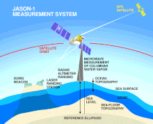
Ocean surface topography can be measured with high accuracy and precision at regional to global scale by satellite altimetry (e.g. TOPEX/Poseidon).
The combination of satellite gravimetry (e.g. GRACE and GRACE-FO) with altimetry can be used to determine sea level rise and properties such as ocean heat content.
According to NASA science this data can also be used to provide understanding of weather, climate, navigation, fisheries management, and offshore operations.
[10] Currently there are nine different satellites calculating the earth ocean topography, Cryosat-2, SARAL, Jason-3, Sentinel-3A and Sentinel-3B, CFOSat, HY-2B and HY-2C, and Sentinel-6 Michael Freilich (also called Jason-CS A).
To monitor the low frequency ocean variability and observe the season cycles and inter-annual variations like El Niño and La Niña, the North Atlantic oscillation, the pacific decadal oscillation, and planetary waves crossing the oceans over a period of months, then they will be modeled over a long period of time due to the precise altimetric observations.
Improvement of tide modeling by observing more long period components such as coastal interactions, internal waves, and tidal energy dissipation.
Finally the satellite data will supply knowledge to support other types of marine meteorology which is the scientific study of the atmosphere.
The long-term objectives of the Jason satellite series are to provide global descriptions of the seasonal and yearly changes of the circulation and heat storage in the ocean.
Studying the transportation of heat and carbon in the ocean and examining the main components that fuel deep water tides.
The satellites data collection also helps improve wind speed and height measurements in current time and for long-term studies.
This study is aimed to provide a comprehensive view of Earth's freshwater bodies from space and more much detailed measurements of the ocean surface than ever before.