Olallie Butte
Located just outside the Olallie Scenic Area, it is surrounded by more than 200 lakes and ponds fed by runoff, precipitation, and underground seepage, which are popular spots for fishing, boating, and swimming.
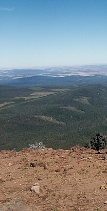
The butte forms a prominent feature in the Mount Jefferson region and is usually covered with snow during the winter and spring seasons.
Olallie Butte is located within Jefferson, Marion, and Wasco counties, all within the northwestern to north-central part[4] of the U.S. state of Oregon.
[4] This region encompasses 13 square miles (34 km2) of an upland area with small volcanoes, bordered to the southwest by the canyon wall of the North Fork of the Breitenbush River.
[4] Williams (1916) reported that Olallie Butte had a number of small, unnamed lakes,[7][8] particularly concentrated at its southern base,[7] which were mostly shallow.
[9] Shitike Creek heads between Olallie Butte and Mount Jefferson, coursing east to the Warm Springs community before it joins the Deschutes River.
[10] Usually covered with snow in the winter and spring seasons,[11] Olallie Butte is a prominent feature in the Mount Jefferson region.
[9] Possessing an average depth of 16.5 feet (5.0 m), Olallie Lake is shallow with rock-bottomed littoral zones and low mineral concentrations of ions, possibly because snow and rain supply most of its water.
[9] In 1975, the Bonneville Power Administration drafted an Environmental Impact Statement for a proposed route through the area, noting that it would disturb the locale's cold, shallow rocky soil, which take long periods of time to form.
The Jefferson Reach's northern portion has an unusually low number of young volcanic centers (early Pleistocene or younger).
[17] Olallie Butte marks part of a region of basaltic andesite eruptions, also prominent at Three Fingered Jack, that extends north and south from Mount Jefferson.
The black and orange color of some of the eruptive material from these cones suggests that there was interaction of the lava with wet ground or snow, causing rapid chilling of the ejecta that prevented oxidation from taking place.
[4] At Double Peaks and an unnamed hill southwest of View Lake, there are gray-pink to light brown-gray hornblende dacite lava domes.
[4] The volcanic cones at Olallie Butte and Mount Jefferson were erupted over deposits from the Minto lava group, which have been deeply eroded to create non-conforming surfaces.
Glacial erosion exposed the central volcanic plug and excavated troughs on Olallie's northeastern side, suggesting that the volcano is at least 25,000 years old.
[4] The domes at Double Peaks and southwest of View Lake have phenocrysts with andesine and dark red-brown basaltic hornblende, the latter of which contained altered magnetite, iron oxide hematite, and other unspecified minerals.
[26] Walker (1982) determined that the Olallie area was not a potential source for commercial deposits of minerals besides low-value rock that might be harvested for construction.
Moreover, no studies have identified fuel repositories in the Olallie area, though Clackamas, Jefferson, Marion, and Wasco counties have been noted for having hot springs and therefore might serve as a future source of geothermal energy.
[34] Olallie Butte has at its summit a United States Forest Service fire lookout tower,[35] which was built in 1915 with a cab and tent cabin.
[40] The western side of the butte can be climbed via a non-maintained trail that gains 2,580 feet (790 m) in elevation from Forest Road 4220, north of Olallie Lake.
[33] This trail passes through tribal land, running for about 3 miles (4.8 km) in length to the summit, where it offers excellent views of Mount Jefferson.
[42] The Olallie Lake Guard Station Cabin, operated by the United States Forest Service, can also be reserved from June through September for a fee of $750 per night.