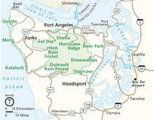
Olympic Peninsula
It is bounded on the west by the Pacific Ocean, the north by the Strait of Juan de Fuca, and the east by Hood Canal.
Comprising about 3,600 square miles (9,300 km2), the Olympic Peninsula contained many of the last unexplored places in the contiguous United States.
It remained largely unmapped until Arthur Dodwell and Theodore Rixon mapped most of its topography and timber resources between 1898 and 1900.
From Olympia, the state capital, U.S. Route 101 runs along the Olympic Peninsula's eastern, northern, and western shorelines.
Major salmon-bearing rivers on the Olympic Peninsula include, clockwise from the southwest, the Humptulips, the Quinault, the Queets, the Quillayute, Bogachiel, the Sol Duc, the Lyre, the Elwha (see Elwha Ecosystem Restoration), the Dungeness, the Dosewallips, the Hamma Hamma, the Skokomish, and the Wynoochee River.