Ontario Highway 35
The winding course of the road, combined with the picturesque views offered along its length, have led some to declare it the most scenic highway in Ontario.
In the mid-1950s, several bypasses were constructed to divert Highway 35 away from town centres including Lindsay, Fenelon Falls and Minden.
Studies are considering whether to widen the route between Enterprise Hill and Lindsay to four lanes, including reconstructing the trumpet interchange at the former.
Several businesses, including gas stations and fast food franchises, line the next portion of the highway interspersed among farmland.
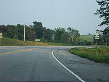
[5] It enters the Oak Ridges Moraine and passes through the eastern edge of the Ganaraska Forest at Enterprise Hill.
[11] The highway travels north in a straight line, passing to the east of Pontypool before exiting the Oak Ridges Moraine near Ballyduff Road.
[12] The terrain flattens approaching Lindsay,[13] where the route intersects Highway 7, onto which it turns west and becomes concurrent.
[15][16] The route curves northeast and travels through farmland as well as the community of Cameron, before turning back northward at Powles Corners, where it intersects the southern end of former Highway 121 (now Kawartha Lakes Road 121).
It continues north a short distance to intersect Kawartha Lakes Road 8, the eastern leg formerly being Highway 35A into Fenelon Falls.
[5][17][18] The highway curves around the southern end of Cameron Lake near Isaacs Glen, travels north for a brief period then zig-zags northeast through Rosedale,[19] where it crosses the Trent–Severn on the Constable Randall F. Skidmore Bridge, named after a local police officer who was involved in a fatal crash nearby on February 14, 1986.
[20] The farmland alongside the highway thins out north of Rosedale, as the route makes its approach to Coboconk.
[5][17] North of the village, the route makes its final descent from the flat limestone plateau into the rocky Canadian Shield.
[17] It begins to follow alongside the Gull River—which it continues to cross and parallel for the remainder of its length—as it curves northeast into Haliburton County.
[17][23][24] Highway 35 generally follows the former Bobcaygeon Colonization Road north of Minden, though several realignments over the years have led to its current winding route.
That volume is fairly consistent as far north as Minden, at which point the vehicle count drops below 5,000 and tapers off as low as 2,000 at Highway 60.
Seeking to open the interior lands of Upper Canada to prospective settlers and farming, the government began the construction of the colonization roads through the wilderness of the southern edge of the Canadian Shield.
[38][39] It was extended north along the road between Fenelon Falls and Rosedale on April 15, 1934, bringing the length of the highway up to 38.9 km (24.2 mi).
The portion lying within Haliburton County, from north of Norland to Dwight and Huntsville, was assumed a month later on October 6.
It then followed today's Kawartha Lakes Road 4 north and west to the current intersection with Highway 35.
[71] Work began later that year to widen the bridge over the Scugog River to accommodate a four lane cross section.
[73] The following table lists the major junctions along Highway 35, as noted by the Ministry of Transportation of Ontario.
[31][78] The short 2.7-kilometre (1.7 mi) route remained in the provincial highway system until April 1, 1997, when it was transferred to Victoria County.
[76] It was created when the Lindsay Bypass was opened on October 10, 1958, redirecting the combined Highway 7/35 southwest of the town.
It then followed today's Kawartha Lakes Road 4 north and west to the current intersection with Highway 35, a distance of 8.8 kilometres (5.5 mi).