OpenCellID
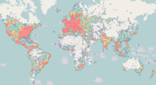
OpenCelliD is a collaborative community project that collects GPS positions of cell towers and their corresponding location area identity.
[citation needed] OpenCelliD publishes an aggregate data set of cell locations licensed under a Creative Commons Attribution-ShareAlike 4.0 International License with the intention of promoting free use and redistribution of the data.
Using Cell ID locations to find device location is more power efficient and often faster[1] than using satellite-based navigation systems, although it is less precise because of the lack of known Cell IDs.
[2] The database is also used to determine the strength of available wireless connections and which mobile phone service providers have coverage in specific geographic locations.
[3] This data is primarily contributed by smartphone users who have installed apps, such as OpenCelliD[4] or OpenCelliD Client,[5] and commercial tracking devices such as blackboxes, but also by wholesale data donation by corporations.