List of Ontario colonization roads
The colonization roads were created during the 1840s and 1850s to open up or provide access to areas in Central and Eastern Ontario for settlement and agricultural development.
One early road was cut through the geographic Beverley Township from Ancaster westward toward the Grand River by two Englishmen named Ward and Smith in 1799–1800.
[3] By this time, a number of townships had been established along the northern shores of Lake Erie and Lake Ontario, which contained generally fertile land composed of glacial till and clay-rich loam; at this time, Upper Canada was "essentially one long, thin strip of settlement"[3] along these shores, according to historian Andrew Burghardt.
As these townships filled up, development pressure increased toward the interior, but the colonial government struggled to maintain Upper Canada's principal roads and bridges.
[4] London, which during the 1820s and 1830s was one of the few major settlements in Upper Canada that was not situated on a lake or canal, relied heavily on road connections.
[4] Numerous road companies suffered from financial problems; Burghardt notes that "[i]t is clear that before the advent of the railway it was difficult to supply adequate means of land transportation at a bearable cost.
"[5] By this time, the focus of development had shifted toward Western Ontario, and new roads to the interior were laid out under the auspices of colonization companies.
[6] As these areas also filled, the government came under pressure to open up the unforgiving terrain of the Canadian Shield to settlement and sought to establish a network of east–west and north–south roads between the Ottawa Valley and Georgian Bay.
[7] In 1847, an exploration survey was carried out by Robert Bell to lay out the lines that would become the Opeongo, Hastings, and Addington Roads.
The government subsequently built over 1,600 kilometres (1,000 mi) of roads over the following 20 years to provide access to these grants.
In October 2016, the imagineNATIVE Film + Media Arts Festival premiered a documentary titled Colonization Road at the TIFF Bell Lightbox in Toronto.
The film has toured throughout Canada, and in January 2017, the Firsthand program on CBC Television aired a broadcast version of Colonization Road.
[10] The terrain these roads pass through is interlaced with many hills, lakes, forests, swamps and bedrock outcroppings.
At the town of Cheddar, the road briefly jogged west following Highway 118 to the former community of Cope Falls.
In the words of the Peterborough Review,[21] "The Monck Road is intended to traverse the entire back country from East to West, and to be adapted to military purposes."
Present-day road names have been preserved along the route in Orillia, Norland, Kinmount, Cardiff and Bancroft.
It was a water and land route that began at Port Arthur, Ontario (now Thunder Bay) and ended at St. Boniface, Manitoba (now Winnipeg).
After crossing Lake of the Woods, the road continued for approximately 10 miles (16 kilometres) through the U.S. at Northwest Angle, overland back into Canada to Richer, Manitoba and then to its end at St. Boniface.
Segments of Dawson Road in and around Winnipeg remain in use, but are disconnected by the Red River Floodway, the Perimeter Highway, and Lagimodiere Boulevard.
MOM's Way is a network of highways that serve as a modern day successor to Dawson Road between Winnipeg and Thunder Bay.
A cairn and plaque commemorating the Dawson Road was erected by the Historic Sites and Monuments Board of Canada in 1933.
Much of the Dawson Trail was abandoned after the completion of the railroad between Fort William and Winnipeg in the 1880s, although local residents continued to make use of the roads.
It was constructed westward from Renfrew beginning in 1854, reaching as far as the Hastings Road in Whitney by 1865; thereafter the survey line continued to Opeongo Lake.
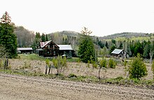
Thirteen pioneer families took up occupation on the land they had been granted up a mountainside 6 kilometres (3.7 mi) off the main road.
These families struggled to farm the rocky soil for thirty years, from the 1860s to the 1890s, while their settlement failed to attract institutions or other settlers.
More recently, the ruined log cabins have occasionally attracted photographers due to their high level of preservation.
The original road went through what is now Canadian Forces Base Petawawa and the Atomic Energy lands north of the town of Chalk River.
Today, the section from Bracebridge to Maynooth has mostly been consumed by the forest, though Highway 118 follows adjacent to the old road as far as Haliburton.
The Northern and Pacific Junction Railway built between Gravenhurst and Callander rendered the Rosseau-Nipissing road obsolete by 1886, yet much of it is still often used.
The Victoria Road continued north of its current terminus in Uphill into what is now the Queen Elizabeth II Wildlands Provincial Park.