Oranjestad, Aruba
Oranjestad (UK: /ɒˈrænjəstɑːt/ orr-AN-yə-staht,[2] US: /ɔːˈrɑːn-, oʊˈrɑːn-/ or-AHN-, oh-RAHN-,[3][4] Dutch: [oːˈrɑɲəstɑt]; literally "Orange City"), the capital and most populous of Aruba's eight regions, is located on the southwestern coast of the island.
[1] Since 1754, European settlers established modest plantations along Aruba's south coast and the flat northwestern region, leading to the emergence of the first residential centers.
However, the primary trade involved importing goods from Curaçao, which were then smuggled ashore using small vessels along the Venezuelan coast, in Coro, and nearby areas.
Although the exact date of the commander's move to Playa is unknown, Fort Zoutman was erected in 1798, marking a significant period when traders shifted from Ponton to Paardenbaai.
[16] The trade boom, however, saw a decline around 1822 or 1823 due to a civil war, during which Simon Bolivar and the independence movement expelled the Spaniards from South America.
The village was described in 1837 as "of great size but so irregularly built that it resembles more a heap of scattered houses than anything that can be called a city".
[21] Socotoro was not the sole plantation or area in Oranjestad to have cultivated the cochineal mites; Companashi, Mon Plaisir, and Sividivi were also included.
[24] In terms of geomorphology, Oranjestad is situated on limestone sediments from the Early Miocene, dating back to approximately 24 Ma.
Additionally, the Important Bird Area MPA Oranjestad Reef Islands is located adjacent to the main harbor.
Temperatures are high year-round, the air is humid with low diurnal temperature variation also year-round, whilst rainfall is very low due to the region lying in a zone of divergence between the southeast trade winds to the south and the North American Monsoon further north.
The exception to this aridity occurs during the short rainy season from September to January when the southward retreat of the Intertropical Convergence Zone generates more frequent moist northeasterly winds.
Due to increased government interest in maintaining the island's cultural heritage, a number of old buildings and houses in the center of town have been transformed into colorfully restored landmarks, such as the lime-colored City Hall on Wilhelminastraat.
[33] Tiara Air has had its head office in Oranjestad since 2006, except between 2014 and 2016 when the company suspended services due to the Venezuelan Airline Crisis.
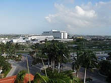
[42] Oranjestad is conveniently connected to the Queen Beatrix International Airport, located 2.5 kilometres (1.6 mi) from the city center.
[46] Plans are underway to enhance loading capacity at Oranjestad, including the construction of a marina to address the insufficient docking space for yachts and fishing boats.
[47] Oranjestad is home to the University of Aruba, which offers programs in law and economics, and to the island's largest secondary school (Colegio Arubano), both modeled on the Dutch system.