Oregon Coast
[6] Minor land variation, city size, and socioeconomic differences between the North and Central regions cause division between them to be made along geological lines.
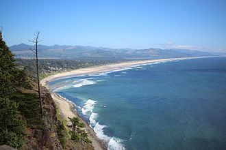
[6] The North Coast, which stretches from the Columbia River to Cascade Head, possesses longer stretches of unbroken beach (due to silt deposits washed southwards from the Columbia River), a higher concentration of logging zones,[citation needed] and larger, but less frequent sandbar-enclosed bays.
Because of the low lands that exist on this region of coast, flooding is an annual problem, especially in the winter, when storms push in from the North Pacific.
Future uplift from the subduction of the Juan de Fuca Plate will eventually create sandstone cliffs similar to those found further south and north.
Higher layers of exposed sandstone are often varying shades of orange, and are often quite soft to the touch, often being very brittle, and relatively easily eroded.
There are seven incorporated cities on the south coast: Reedsport, North Bend, Coos Bay, Bandon, Port Orford, Gold Beach, and Brookings.
Cape Blanco, which is approximately 6.4 miles (10.3 km) north of Port Orford, is the westernmost point in Oregon.
Because of the Oregon Coast's physical complexity, many different species of plant and animal can be found in the region, both terrestrial and marine in nature.
[9] Due to several factors, including climate, weather, and terrain, there is a great variety of plants within the coast region.
In the North Coast region near Astoria, and in Lincoln County, large tracts of land are second and third generation woodland, having been logged and replanted in the past.
Because of the salt carried inland by constant onshore winds, only the hardiest varieties of small plant can thrive close to shore.
Likewise, smaller species, including nutrias and Virginia opossum can also be found, as well as the Townsend's mole, which inhabits many lowland and floodplain areas.
[16] Tidepools, which occur frequently along Oregon's rocky shores, are unique, contained ecosystems housing up to many hundreds of species of animal.
[21] It is generally accepted that the first indigenous peoples arrived in the region around 11,000–13,000 years ago, likely drawn by the rich natural resources of the area.
The earliest expedition recorded along the Pacific Northwest coast, however, was led by Spaniard Juan José Pérez Hernández aboard the sloop Santiago in 1774.
However, Gray accidentally grounded the Washington on a sand bar, and the ship was attacked by natives, in which one crew member was killed and the mate wounded.
Gray returned in 1792 aboard the Columbia, where he met with British Captain Vancouver off the Strait of Juan de Fuca.
Vancouver quietly dismissed this claim by Gray, thinking that the Columbia was a part of the Juan de Fuca Strait.
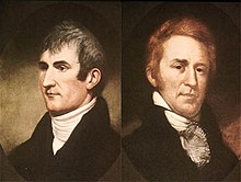
[25] In 1803, with the successful purchase of the Louisiana Territory from France, President Thomas Jefferson ordered an expedition to the west coast, which was led by Captain Meriwether Lewis and William Clark.
The Lewis and Clark Expedition reached the Oregon Coast in early winter of 1805, where they built Fort Clatsop near present-day Astoria.
Oregon's public lands claim was challenged in 1966, when a motel owner fenced off beach area for the private use of his guests.
[29][32] In response, Governor Tom McCall staged a dramatic media event on May 13, 1967, flying two helicopters to the beach with a team of surveyors and scientists.
The ensuing media coverage resulted in overwhelming public demand for the bill, which passed and was signed by McCall on July 6, 1967.
The public has "free and uninterrupted use of the beaches," and property owners are required to seek state permits for building and other uses of the ocean shore.
[34] While some parts of the beach remain privately owned, state and federal courts have upheld Oregon's right to regulate development of those lands and preserve public access.
Hiking, sport fishing, cycling, kite flying, scuba diving, surfing, sandboarding, and boating are common activities for visitors to the region.
Some beaches are also shrinking, due partially to human interactions and partly to invasive species of plant such as European Beachgrass.
Because the Oregon and Washington coasts have been traditionally thought of as some of the most dangerous seas in the world, several lighthouses and a lightship were commissioned to aid sailors in navigating.
The homesteaders eventually abandoned their claims in favor of living closer to the nearby rural villages and towns.
Finally, Oregon has the distinction of being the only U.S. state (Hawaii and Alaska did not attain statehood until 1959) to receive hostile action during World War II, being both shelled and bombed.