Orkney
[25][Notes 2] A charred hazelnut shell, recovered in 2007 during excavations in Tankerness on the Mainland, has been dated to 6820–6660 BC, indicating the presence of Mesolithic nomadic tribes.
[35][36][37] During the Bronze Age, fewer large stone structures were built (although the great ceremonial circles continued in use[38]) as metalworking was slowly introduced to Britain from Europe over a lengthy period.
[46][47] During the Roman invasion of Britain the "King of Orkney" was one of 11 British leaders who is said to have submitted to the Emperor Claudius in AD 43 at Camulodunum (modern Colchester).
[56] It has been suggested that an assault by forces from Fortriu in 681 in which Orkney was "annihilated" may have led to a weakening of the local power base and helped the Norse come to prominence.
[61][Notes 5] He was succeeded by his son Thorfinn Skull-splitter and during this time the deposed Norwegian King Eric Bloodaxe often used Orkney as a raiding base before being killed in 954.
Along with Sigurd's other sons he ruled Orkney during the first half of the 11th century and extended his authority over a small maritime empire stretching from Dublin to Shetland.
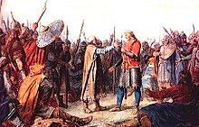
[79] In 1290, the death of the child princess Margaret, Maid of Norway in Orkney, en route to mainland Scotland, created a disputed succession that led to the Wars of Scottish Independence.
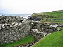
[83][Notes 12] Evidence of the Viking presence is widespread and includes the settlement at the Brough of Birsay,[86] the vast majority of place names,[87] and the runic inscriptions at Maeshowe.
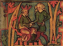
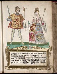
[Notes 13] In 1468 Orkney and Shetland was pledged by Christian I, in his capacity as King of Norway, as security against the payment of the dowry of his daughter Margaret, betrothed to James III of Scotland.
An influx of Scottish entrepreneurs helped to create a diverse and independent community that included farmers, fishermen and merchants that called themselves comunitas Orcadie and who proved themselves increasingly able to defend their rights against their feudal overlords.
[94] Agricultural improvements beginning in the 17th century resulted in the enclosure of the commons and ultimately in the Victorian era the emergence of large and well-managed farms using a five-shift rotation system and producing high-quality beef cattle.
The harsh winter weather of Orkney and the Orcadian reputation for sobriety and their boat handling skills made them ideal candidates for the rigours of the Canadian north.
At the end of the 1715 rebellion, a large number of Jacobites who had fled north from mainland Scotland sought refuge in Orkney and were helped on to safety in Sweden.
[99] In 1745, the Jacobite lairds on the islands ensured that Orkney remained pro-Jacobite in outlook and was a safe place to land supplies from Spain to aid their cause.
The problem of a declining population was significant in the post-war years, though in the last decades of the 20th century, there was a recovery and life in Orkney focused on growing prosperity and the emergence of a relatively classless society.
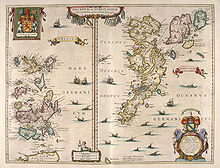
[108] Orkney is separated from the mainland of Scotland by the Pentland Firth, a ten-kilometre-wide (6 mi) seaway between Brough Ness on the island of South Ronaldsay and Duncansby Head in Caithness.
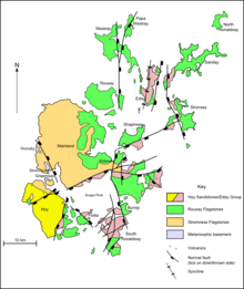
[126] Glacial striation and the presence of chalk and flint erratics that originated from the bed of the North Sea demonstrate the influence of ice action on the geomorphology of the islands.
Burray lies to the east of Scapa Flow and is linked by causeway to South Ronaldsay, which hosts cultural events such as the Festival of the Horse and the Boys' Ploughing Match on the third Saturday in August.
In 2022, as part of the Levelling Up White Paper, an "Island Forum" was proposed, which would allow local policymakers and residents in Orkney to work alongside their counterparts in Shetland, the Western Isles, Anglesey and the Isle of Wight on common issues, such as broadband connectivity, and provide a platform for them to communicate directly with the government on the challenges island communities face in terms of levelling up.
[171] The soil of Orkney is generally very fertile and most of the land is taken up by farms, agriculture being by far the most important sector of the economy and providing employment for a quarter of the workforce according to a 2008 report.
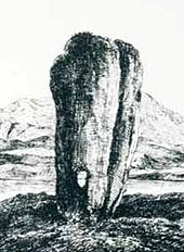
The Hoy area's landscape is also attractive to visitors, "with its scattered woodland, steep valleys, high cliffs and the famous Old Man, a withered red sandstone sea stack".
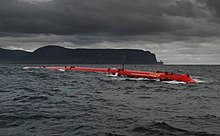
[188] At the official opening of the Eday project the site was described as "the first of its kind in the world set up to provide developers of wave and tidal energy devices with a purpose-built performance testing facility.
A new cable could be laid for exporting of energy to the mainland but another proposal has progressed rapidly since that time: making "excess renewable power into another fuel – such as hydrogen – and then [storing] it".
[200] A few weeks earlier, another report indicated that the world's first hydrogen-fueled ferry was to be tested on the Orkney Islands, using "a hydrogen/diesel dual fuel conversion system", developed by a consortium known as the HyDIME project.
[226][Notes 21] Orkney has a rich folklore, and many of the former tales concern trows, an Orcadian form of troll that draws on the islands' Scandinavian connections.
[239][240] Native Orcadians refer to the non-native residents of the islands as "ferry loupers" ("loup" meaning "jump" in the Scots language),[241] a term that has been in use for nearly two centuries at least.
[242][Notes 22] Orkney has an abundance of wildlife, especially of grey and common seals and seabirds such as puffins, kittiwakes, black guillemots (tysties), ravens, and great skuas (bonxies).
[246] The North Ronaldsay sheep is an unusual breed of domesticated animal, subsisting largely on a diet of seaweed, since they are confined to the foreshore for most of the year to conserve the limited grazing inland.
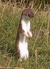
[257] Not all was going well as of 15 January 2021, according to The Times, which stated that the project "has been hit by alleged sabotage after the destruction and theft of traps that have also killed and injured household pets and other animals" but added that the £6 million programme was supported by most islanders.
[259] A subsequent report confirmed that "Police Scotland is investigating a number of incidents involving damage to and the theft of stoat traps in Orkney".