Outer Barrier
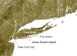
The outer barrier extends 75 miles (121 km) along the South Shore of Long Island, from the Rockaway Peninsula in New York City to the east end of Shinnecock Bay in Suffolk County.
The low-lying islands are subject to wave erosion, and, during storms, they are sometimes inundated and cut through.
Jones Beach State Park, on the western tip of the island is a summer recreational destination for the New York City area.
Fire Island passes through southern Suffolk County, New York, and is southeast of Long Island separated from the main land by the Great South Bay in the U.S. state of New York, running approximately SW to NE.
The largest of these is Fire Island (CDP), which is unincorporated and stretches through the southern portion of the towns of Babylon, Islip, and Brookhaven.
There are several ocean front communities such as, Davis Park and Watch Hill that are on the eastern side of the Great south bay.
It connects the Great South Bay with the Atlantic Ocean, passing between Robert Moses State Park (the western end of Fire Island) on the south and Oak Beach and Captree State Park (the eastern end of Jones Island) on the north.
Cupsogue Beach County Park is located on the western end of the island.
The inlet created a geographic oddity whereby the Town of Brookhaven actually has jurisdiction on land immediately west of the village of West Hampton Dunes although Brookhaven land access to it involves a nearly 20 mile drive through Southampton.
Shinnecock Inlet is the easternmost of five major inlets[4] connecting bays to the Atlantic Ocean through the narrow 100-mile-long barrier islands that stretch from New York City to Southampton, New York on the south shore of Long Island.
The inlet was formed by the Great Hurricane of 1938 which killed several people when it permanently broke through the island in Hampton Bays, New York.