Outline of Mali
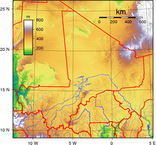
[1] It is the seventh most extensive country in Africa, bordering Algeria on the north, Niger on the east, Burkina Faso and the Côte d'Ivoire on the south, Guinea on the south-west, and Senegal and Mauritania on the west.
Consisting of eight regions, Mali's borders on the north reach deep into the middle of the Sahara, while the country's southern region, where the majority of inhabitants live, features the Niger and Senegal rivers.
Some of Mali's natural resources include gold, uranium, and salt.
Due to a high incidence of poverty, Mali is considered to be one of the poorest nations in the world.
After a long period of one-party rule, a 1991 coup led to the writing of a new constitution and the establishment of Mali as a democratic, multi-party state.