Outline of Tuvalu
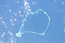
Comprising three reef islands and six true atolls with a gross land area of just 26 square kilometers (10 sq mi) it is the third-least populated independent country in the world, with only Vatican City and Nauru having fewer inhabitants.
Therefore, the origins of the people of Tuvalu are addressed in the theories regarding the spread of humans out of Southeast Asia, from Taiwan, via Melanesia and across the Pacific islands to create Polynesia.
[5] Keith S. Chambers and Doug Munro (1980) identify Niutao as the island that Francisco Mourelle de la Rúa sailed past on 5 May 1781, thus solving what Europeans had called The Mystery of Gran Cocal.
[4][6] Mourelle's map and journal named the island El Gran Cocal ('The Great Coconut Plantation'); however, the latitude and longitude was uncertain.
[7] Geographic coordinates: 5°41′S 176°12′E / 5.683°S 176.200°E / -5.683; 176.200 to 10°45′S 179°51′E / 10.750°S 179.850°E / -10.750; 179.850 Tuvalu consists of three reef islands and six true atolls, whose highest point above the sea is five metres.