Overdeepening
These overdeepened cuts into bedrock structures can reach a depth of several hundred metres below the valley floor.
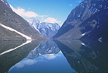
The strongest indication for glacial erosion is the overdeepening of fjord floors well below present and past sea level and their outer rock threshold.
Measured in volume eroded within a limited time span, an ice stream forming its own clearly defined drainage channel (fjord) is apparently one of the most significant erosive agents in operation on Earth.
[3] Fjord lakes are commonly formed in mountainous regions which channel ice flows through narrow valleys.
Although they exist in many countries, the fjord lakes found in British Columbia, Canada, are illustrative of their nature.
Similar fjord lakes in excess of 100 km (62 mi) in length are found elsewhere in British Columbia.
[4] Kootenay Lake located between the Selkirk and Purcell mountain ranges in the Kootenay region of British Columbia is approximately 100 km (62 mi) in length and 3–5 km in width formerly discharged through the Purcell Trench into Lake Missoula in Montana.
Their cross-sections exhibit steep sided flanks (similar to fjord walls) and flat bottoms typical of subglacial glacial erosion.
The floor of the cirque ends up bowl shaped as it is the complex convergence zone of combining ice flows from multiple directions and their accompanying rock burdens, hence experiences somewhat greater erosion forces, and is most often scooped out somewhat below the level of cirque's low-side outlet (stage) and its down slope (backstage) valley.
Although research remains in fully understanding the processes involved, significant progress has been evident in the late 20th and early 21st centuries.
Glaciologists performed a detailed radar survey of Antarctica's Gamburtsev Mountains during the International Polar Year, allowing both the overlying glacial ice thickness and the elevation of the bedrock below to be found.
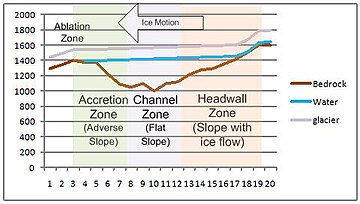
Water flowing down the headwall gains energy, which melts the surrounding ice, creating channels.
[10] Surface water drains via moulins to a subglacial system of conduits which allow flow into cavities in the ice.
This variation is thought to contribute to quarrying of blocks from the headwall combined with the erosive powers of rapidly moving debris streams entrained in flowing water.
The hydraulic pressure of the water becomes significant – it is driven by surface slope of the overlying ice and by the bed topography.
The hydraulic pressure offsets part of the weight of the glacier (the lower density ice tends to be displaced by water).
The largest glacial movements were observed during periods of transition, as increasing water was released into the glacier.
[13] Analytic glacial erosion models suggest that ice flows passing through constrained spaces such as mountain passes produced enhanced erosion beneath thicker, faster ice flows, which deepens the channel below areas both upstream and downstream.
When there is a significant increase in the elevation on the adverse slope, ice grows from supercooling of streams flowing up the overly steep face of the moraine shoal causes transport capacity to drop below load delivered, producing deposition to fill the adverse face of the overdeepening back towards the supercooling threshold.
Ice lenses will form within the bedrock, accumulating until the rock is sufficiently weakened that it shears or spalls off.
Since the rate of glacier movement is dependent upon the characteristics of this basal ice, research is ongoing to better quantify the phenomena.
In what is referred to as the Messinian salinity crisis the Mediterranean Sea basin was geologically separate from the Atlantic Ocean.