Oxnard Plain
The population within the plain comprises a majority of the western half of the Oxnard-Thousand Oaks-Ventura Metro Area and includes the largest city along the Central Coast of California.
The high quality soils, adequate water supply, favorable climate, long growing season, and level topography are characteristic of the Oxnard Plain where the top cash crops are strawberries, raspberries, nursery stock and celery.
The diversity of natural resources along with the temperate climate with a long growing season produced a lengthy archaeological record of human activity along the coast.
They also experienced further disruptive contacts through the increasing number of Europeans and Americans that visited the California coast looking for pelts from fur-bearing animals such as sea otters, and trade in hides and tallow beginning in the 1790s.
The destruction wrought by the livestock and shortages of wild plants that they used for food may have made the missions appear to be the only viable alternative to a disintegrating way of life.
The Chumash culture, including political and social relationships between communities, trade, and inter-village marriage patterns, could not be sustained as more and more Indians abandoned their traditional way of life and entered the mission.
With the secularization of the missions by the Mexican government in June 1836, their lands were granted as rewards for loyal service or in response to petitions by individuals.
[23] In 1887, as the railroad was constructed from Los Angeles to the town of San Buenaventura, the Montalvo station was established on the plain on the north side of the river.
In 1898 the Montalvo Cutoff brought the railroad across the Santa Clara River at El Rio and then due south to where the town of Oxnard was being established.
The Oxnard Brothers built the American Beet Sugar Company factory on land in the middle portion of the plain that they bought from James Saviers.
[17] The railroad continued with tracks heading east out of Oxnard and eventually being extended to Santa Susana in Simi Valley.
Traffic on the coast railroad line was rerouted through Oxnard in 1904 with the completion of the Santa Susana Tunnel as this became the most direct route between Los Angeles and San Francisco.
While one ethnic group can often be pitted against another to undermine labor solidarity, the Oxnard Strike of 1903 unified them, as their efforts brought the industry to a standstill until their demands were met.
[26] In 1911, J. Smeaton Chase noted the "prosperous fields of beans and beets" as he descended from the Santa Monica Mountains onto the Oxnard Plain during his 2,000-mile (3,200 km) horseback journey from Mexico to Oregon.
In his book about the journey, he describes the "sleepy little coast village of Hueneme" as a "ghost of a once flourishing town" due to the establishment of a beet sugar factory.
[31] "Save Open-space and Agricultural Resources" (SOAR) was the name given to these plans that would limit housing and commercial development on farmland surrounding the cities.
[41][42] While the vast fields of fertile soil were appreciated for the agricultural bounty that could be produced, the sand dunes and wetlands along the coast line were considered useless except as places to dispose of solid and liquid waste.
[43] The Halaco Engineering Co., a metal recycling facility at the Ormond Beach wetlands, deposited process wastes and wastewater from the smelter from 1965 until 2004 on what was allegedly a former open dump operated by the City of Oxnard until 1962.
[44] Other large, polluting industries were cited at Ormond Beach wetlands before environmental concerns highlighted the importance of restoring the area to serve as a dynamic habitat for a wide array of native plants and animals.
Three dump sites about 2 miles (3.2 km) upstream from the mouth of the river came under the control of the Ventura Regional Sanitation District by 1988.
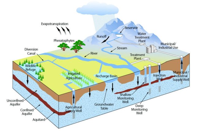
It has been formed chiefly by the deposition of sediments from Santa Clara River Valley and the watershed of Calleguas Creek before they flow into the Pacific Ocean.
[6] The alluvial deposits from these rivers are generally a few hundred feet (30 metres) thick and lie over Pleistocene and Pliocene sedimentary rocks.
[53]: xix Historically, Calleguas Creek flood flows spread across the floodplain and the deposited sediment created the rich agricultural lands of the Oxnard Plain.
In response, the Ventura County Board of Supervisors passed an emergency ordinance that halted well-drilling in the Oxnard Plain.
[56] The United Water Conservation District funded a detailed feasibility study in 2014 and found that the impaired groundwater in the south Oxnard Plain is suitable for treatment by reverse osmosis at an acceptable recovery range of 72 to 80 percent.
Gradually, pipelines begin serving city parks, street medians, and all the landscaping in new developments including two along the Santa Clara River: RiverPark, a community of 1,800 homes and Wagon Wheel with 1,500 apartments and condos.
The District encompasses about 214,000 acres (87,000 ha)[75] and owns Lake Piru and key facilities along the Santa Clara River that are used to manage groundwater supplies.
The National Marine Fisheries Service determined that fixing this was a high priority since it is the first structure the steelhead encounter when attempting to migrate from the ocean.
[83] United released water from Lake Piru to specifically recharge the Fox Canyon in the Oxnard Plain for the first time in 2019.
The expansion of agriculture and industry have drained, filled and degraded much of the wetlands over the past century but the area does have a dune-transition zone–marsh system along much of two-mile-long beach (3.2 km) that extends from Port Hueneme to the northwestern boundary of Point Mugu Naval Air Station.