Balochistan, Pakistan
Balochistan is an extensive plateau of rough terrain divided into basins by ranges of sufficient heights and ruggedness.
[16] Although during the Stone and Bronze Age and Alexander the Great's empire an indigenous population existed, the Baloch people themselves did not enter the region until the 14th century CE.
[18] In 654, Abdulrehman ibn Samrah, governor of Sistan and the newly emerged Rashidun caliphate at the expense of Sassanid Persia and the Byzantine Empire, sent an Islamic army to crush a revolt in Zaranj, which is now in southern Afghanistan.
[19] It is documented that the major settlements, falling within today's province, became in 654 controlled by the Rashidun caliphate, except for the well-defended mountain town of QaiQan which is now Kalat.
He was a close aide of the Timurid ruler Humayun, and was succeeded by the Khanate of Kalat, which owed allegiance to the Mughal Empire.
[22][23][24] Ahmad Shah Durrani, founder of the Afghan Empire, also won the allegiance of that area's rulers, and many Baloch fought under him during the Third Battle of Panipat.
[25] During this time from the fall of the Durrani Empire in 1823, four princely states were recognised and reinforced in Balochistan: Makran, Kharan, Las Bela and Kalat.
In 1876, Robert Sandeman negotiated the Treaty of Kalat, which brought the Khan's territories, including Kharan, Makran, and Las Bela, under British protection, even though they remained independent princely states.
[29][30] In British-ruled Colonial India, Baluchistan contained a Chief Commissioner's province and princely states (including Kalat, Makran, Las Bela and Kharan) that became a part of Pakistan.
[34]: 81 The then-president of the Baluchistan Muslim League, Qazi Muhammad Isa, informed Muhammad Ali Jinnah that "Shahi Jirga in no way represents the popular wishes of the masses" and that members of the Kalat State were "excluded from voting; only representatives from the British part of the province voted and the British part included the leased areas of Quetta, Nasirabad Tehsil, Nushki and Bolan Agency.
[37] Princes Agha Abdul Karim Baloch and Muhammad Rahim refused to lay down arms, leading the Dosht-e Jhalawan in unconventional attacks on the army until 1950.
Bugti implicated India's Research and Analysis Wing (RAW) of being responsible for recent attacks at military bases in Smangli and Khalid, and for subverting the China–Pakistan Economic Corridor (CPEC) agreement.
The province is bordered by Afghanistan to the north and north-west, Iran to the south-west, Punjab and Sindh, and Khyber Pakhtunkhwa and the Federally Administered Tribal Areas to the north-east.
Balochistan lies at the mouth of the Strait of Hormuz and provides the shortest route from seaports to Central Asia.
The capital city Quetta is located in a densely populated portion of the Sulaiman Mountains in the northeast of the province.
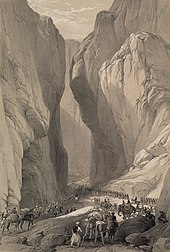
It is situated in a river valley near the Bolan Pass, which has been used as the route of choice from the coast to Central Asia, entering through Afghanistan's Kandahar region.
In the lower highlands, winters vary from extremely cold in northern districts Ziarat, Quetta, Kalat, Muslim Baagh and Khanozai, where temperatures can drop to −20 °C (−4 °F), to milder conditions closer to the Makran coast.
The ceremonial head of the province is the Governor, who is appointed by the President of Pakistan on the advice of the provincial Chief Minister.
The judicial branch of government is carried out by the Balochistan High Court, which is based in Quetta and headed by a Chief Justice.
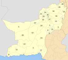
[39] For administrative purposes, the province is divided into seven divisions: Kalat, Makran, Nasirabad, Quetta, Sibi, Zhob and Rakhshan.
In March 2012, preliminary census figures showed that the population of Balochistan, not including the districts of Khuzdar, Kech and Panjgur, had reached 13,162,222, an increase of 139.3% from 5,501,164 in 1998.
In the Lasbela, Hub districts and in Kachhi plain region a large minority of the population speaks Lasi and Siraiki,[60] which are dialects of Sindhi.
[61] According to the Ethnologue, households speaking Balochi, whose primary dialect is Makrani constitutes 13%, Rukhshani 10%, Sulemani 7%, and Khetrani 3% of the population.
Other languages spoken are Lasi, Urdu, Punjabi, Hazargi, Sindhi, Saraiki, Dehvari, Dari, Tajik, Hindko, Uzbek, and Hindki.
[80] The economy of Balochistan is largely based upon agriculture, livestock, fisheries, production of natural gas, coal and other minerals.
[81] Though agriculture and livestock play a dominant role in the provincial economy by contributing 47% of its GDP, it faced intense damages due to the 2022 Pakistan floods.
[85][86] Although the province is rich in natural resources capable of uplifting its economy, most of them have not been fully utilised for the welfare of the population and are yet to be explored or developed.
[92] Several major development projects, including the construction of a new deep sea port at the strategically important town of Gwadar,[93] are in progress in Balochistan.
The port is projected to be the hub of an energy and trade corridor to and from China, Middle East and the Central Asian republics.