Pakuranga
[3][4] In the 19th Century, inland Pakuranga was a peat wetland, dominated by Cordyline australis (tī kōuka / cabbage trees).
[5] The name Pakuranga is a contraction of Te Pakuranga-rāhīhī ("The Battle of the Sun's Rays"), a traditional Tāmaki Māori story involving a battle between the supernatural Tūrehu people of the Waitākere and Hunua ranges, where magic was used to turn warriors into stone using the sun's rays.
The gods Mataaho and Rūaumoko, after hearing of this battle, create the Auckland volcanic field in their rage.
[7][10] The name Pakuranga was used by early European settlers from the 1840s to refer to the area between the Tāmaki River and Tūranga Creek.
[11] After the establishment of Howick, the name Pakuranga referred to the rural area to the west of the settlement as far as the Tāmaki River.
Tāiki settled with his followers along the eastern shores of the Tāmaki River, alongside the descendants of Huiārangi of the early iwi Te Tini ō Maruiwi.
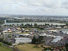
[17] The upper reaches of the river near modern Pakuranga is traditionally known as Te Wai Mokoia, referring to Mokoikahikuwaru, a protector taniwha of the Tainui waka who is described in legends as taking up residence at the Panmure Basin.
[10] By the mid-18th century, Ngāti Pāoa, a Hauraki Gulf tribe with close relationships to Ngāi Tai, established themselves on the western shores of the river at Panmure, at Mokoia pā and a kāinga called Mauināina.
[19][20] By the time missionaries Samuel Marsden and John Gare Butler visited the isthmus in 1820, there were thousands of inhabitants living along the shores of the Tāmaki River at Mokoia.
[23] The land at Mokoia and Mauināina pā became tapu for Ngāti Pāoa due to the large number of deaths, and was not resettled.
[25] In 1854 when Fairburn's purchase was investigated by the New Zealand Land Commission, a Ngāi Tai reserve was created around the Wairoa River and Umupuia areas, and as a part of the agreement, members of Ngāi Tai agreed to leave their traditional settlements to the west.
[27] Much of the area was farmed by Hemi Pepene, a Ngāpuhi orphan who grew up at the Paihia Mission Station and was taken care of by the Fairburns,[27] and by Joseph Hargreaves, who bought 82 acres in 1843 and constructed the first European house in Pakuranga.
[28] In 1847, Howick was established as a defensive outpost for Auckland, by fencibles (retired British Army soldiers) and their families.
[30] Many of the first European farmers in the area were fencibles from Howick,[12] such as brothers Robert and Thomas Every Maclean in 1851 who developed extensive livestock farms,[31] and Patrick and Ann Fitzpatrick who bought land in 1852.
While Māori of South Auckland such as Te Ākitai Waiohua were forced to leave, Ngāi Tai were designated as a "friendly" people by the Crown and remained neutral in the fighting.
[34] In the same year, the capital of New Zealand was moved from Auckland to Wellington, causing major financial problems for the area as land prices plummeted and demand for butter dropped.
[37] By the later 19th Century, Pakuranga developed into an area similar to the English countryside, dominated by poplar, oak and willow trees.
[32] The Pakuranga Hall was opened in 1921,[38] In the 1930s, the road to Howick was concreted, improving transport times for milk to Auckland, and for passengers into the area.
[39] Land in Pakuranga was subdivided into housing from the 1950s, and the Manukau County Council planned to leave a green belt separating Pakuranga from Howick, however lost a court case with a farmer who planned to subdivide his land.
[46] The Eastern Busway, a project to link Botany to Panmure by rapid transport, began construction in 2019.