Panguitch, Utah
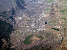
[8] Panguitch is located on the western edge of Garfield County at 37°49′20″N 112°26′5″W / 37.82222°N 112.43472°W / 37.82222; -112.43472 (37.822234, -112.434650),[9] in the valley of the Sevier River.
According to the United States Census Bureau, the city has a total area of 2.1 square miles (5.5 km2), all land.
Maxima, however, can be expected to top freezing on all but fourteen afternoons during an average year, and the winters are so dry that snowfall is light, averaging only 19.2 inches or 0.49 metres with median cover never much above 1 inch or 0.025 metres.
Mild, dry winters like 1976/1977 and 1980/1981 can in contrast see negligible snowfall for an entire season.
In a manner more akin to Arizona than northern Utah, most of the limited precipitation occurs during the July to October monsoon season, but Garfield County is usually too far north to receive the monsoon's full benefit.
Panguitch was first settled in March 1864, when Jens Nielsen, a Danish convert to the Church of Jesus Christ of Latter-day Saints, led a group of 54 families eastward from Parowan and Beaver to the Sevier River.
[13] Due to the area's high elevation, 6,600 feet (2,000 m) above sea level, winter's cold weather arrived early in the year, and most of the settlers' initial crops were killed by frost before they could mature.
[14] Due to the Black Hawk War to the north, church officials decided the settlers should abandon the area, and they did so in May 1865.
[1] The settlers cut lumber from the forests and processed it in sawmills and shingle mills.
Students as young as six were taken from their tribe and forced to live at the school overseen by the federal government.
[16][17] Timber and livestock production were successful industries in Panguitch until the economic shifts following World War I.
November 2010
